SBXP - São Paulo
General data
| TMA | São Paulo TMA |
| Position | SBXP_APP |
| Callsign | São Paulo Control |
| Frequency | 119.600 MHz1 |
| ATS surveillance | Radar |
| Transition altitude | 8000 ft throughout the TMA2 |
| Aerodromes in the TMA | SBGR, SBSP, SBKP, SBMT, SBJD, SBSJ, SDCO, SBST, SDAM, SBJH, SBBP |
Useful Information
Use the tabs above: Aeronautical Charts shows the TMA charts, Visual Charts shows the visual charts (REA/REH) from AISWEB, Weather shows a weather map of the area and VATSIM Traffic opens the traffic at the main aerodrome (SBGR).
Source: AISWEB.
Map
Click a volume to see its limits and class. Use the layer control to change the base map and toggle the volumes.
The Visual corridors (REA) layer shows every aeroplane corridor of the TMA and the Paraíba valley and the aerodrome gates. Solid line: controlled segment; dashed: class G, coordinated on the FCA; arrow: one-way. Click a segment to see the tracks, altitudes and contact. Details in Visual corridors (REA).
The Helicopter routes (REH) layer, off by default, shows the circular's 31 REHs. Solid line: controlled segment (Controle Helicóptero or a Tower); dashed: class G. Route names appear when zoomed in. See Helicopters (REH).
Volumes
| Volume | Limits | Class |
|---|---|---|
| São Paulo 2 (Visual sector) | 3600 FT – 5500 FT | C |
| São Paulo 1 | 5500 FT – FL245 | A C |
| Guarulhos CTR | GND – 3600 FT | D |
| São Paulo CTR (Congonhas) | GND – 3600 FT | D |
| Campinas CTR | GND – 3700 FT | D |
| São José CTR | GND – 5500 FT | D |
| Jundiaí CTR | GND – 4500 FT | D |
| Taubaté CTR | GND – FL085 | D |
| Marte ATZ | GND – 3700 FT | — |
APP Sectorization
The APP is split into sectors, each with its own position and frequency in the package. Turn on the APP sectors (elementary) layer on the map to see them, or the layer of a combined position to see the consolidated area it covers. Who takes over a closed sector is shown under Combined positions and in the coverage diagram.
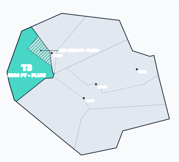
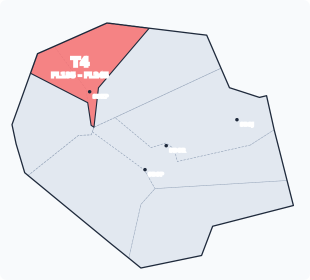
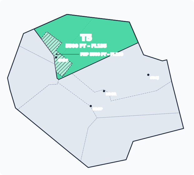
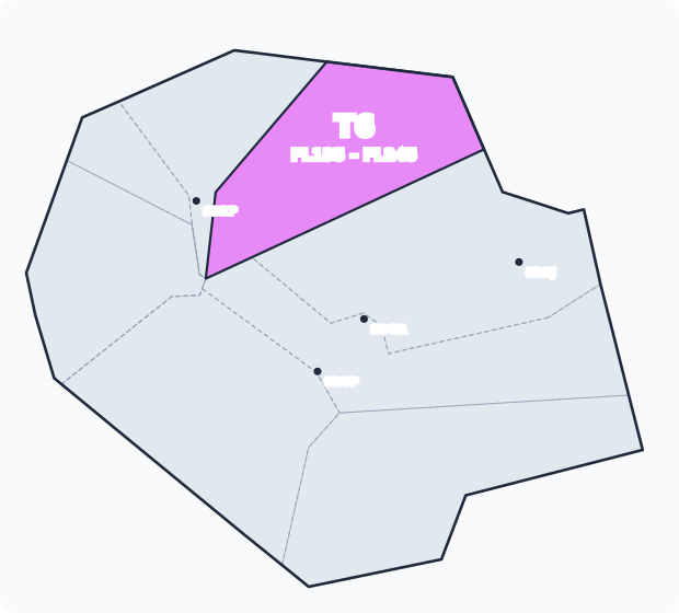
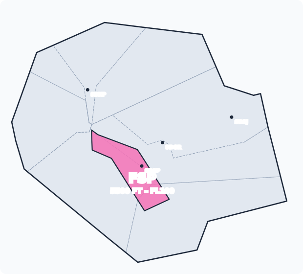
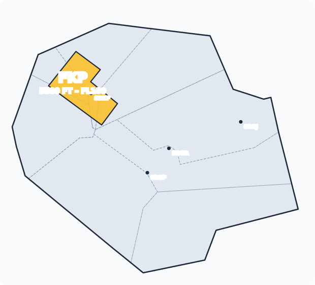
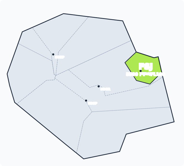
Pick an area in the list: the whole TMA (one position for everything), a combined position or an elementary sector. The area is filled, with its vertical limits below the name; the rest of the TMA is grey. Hatched: the part of the sector that belongs to a final below FL100.
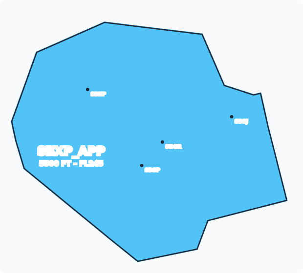
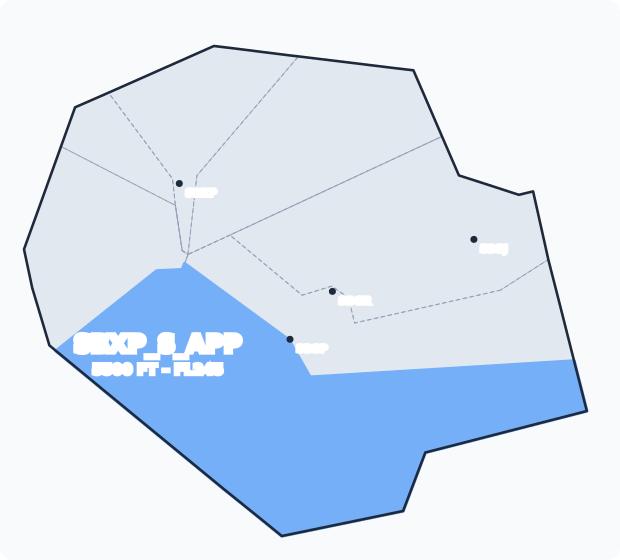
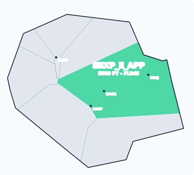
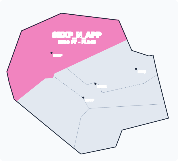
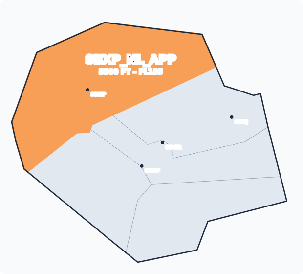
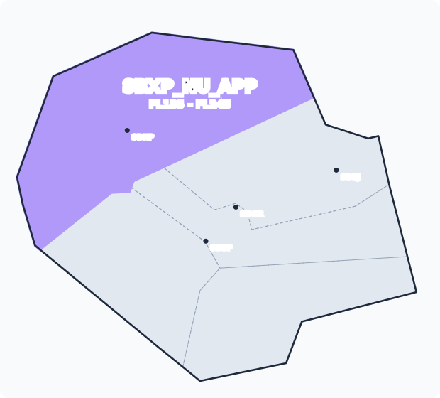
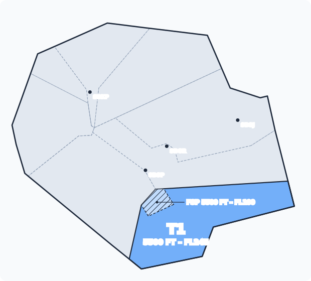
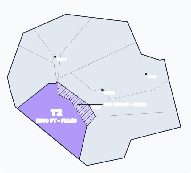
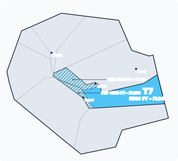
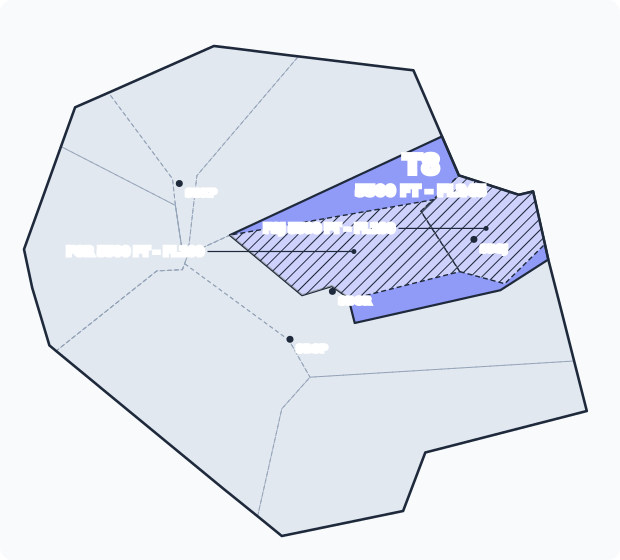
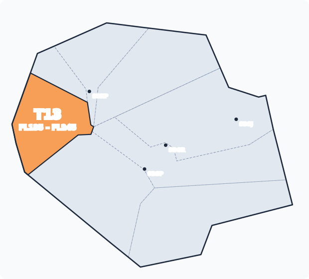
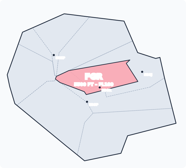
| Sector | Position | Frequency | Limits | Role |
|---|---|---|---|---|
| T1 | SBXP_T1_APP | 134.900 | 5500 FT – FL245 | Feeder for SBSP, to the south |
| T2 | SBXP_T2_APP | 122.750 | 5500 FT – FL245 | Feeder for SBSP, to the west and southwest |
| T3 | SBXP_T3_APP | 135.750 | 5500 FT – FL135 | Feeder for SBKP, to the west |
| T4 | SBXP_T4_APP | 119.800 | FL135 – FL245 | Upper sector: arrivals and departures to the northwest |
| T5 | SBXP_T5_APP | 132.100 | 5500 FT – FL135 | Feeder for SBKP and SBGR, to the north |
| T6 | SBXP_T6_APP | 120.850 | FL135 – FL245 | Upper sector: arrivals and departures to the north and northeast |
| T7 | SBXP_T7_APP | 119.375 | 5500 FT – FL245 | Feeder for SBGR and SBSP, to the east |
| T8 | SBXP_T8_APP | 120.450 | 5500 FT – FL245 | Feeder for SBGR and SBSJ, to the northeast |
| T13 | SBXP_T13_APP | 129.275 | FL135 – FL245 | Upper sector: arrivals and departures to the west |
| FGR | SBGR_F_APP | 129.750 | 5500 FT – FL100 | Final for SBGR |
| FSP | SBSP_F_APP | 133.850 | 5500 FT – FL100 | Final for SBSP |
| FKP | SBKP_F_APP | 119.250 | 5500 FT – FL100 | Final for SBKP |
| FSJ | SBSJ_F_APP | 124.150 | 5500 FT – FL100 | Final for SBSJ |
| V | SBXP_V_APP | 129.500 | 3600 FT – 5500 FT | Visual sector: TMA São Paulo 2 and the VFR corridors |
- Upper sector: takes descending arrivals from the ACC and hands climbing departures to the ACC, above the feeders.
- Feeder: builds the arrival sequence and hands the aircraft to the final already spaced, descending to the final altitude. It also handles departures in its sector.
- Final: takes traffic from the feeders, adjusts the spacing on final and transfers to the Tower.
- Visual sector: controls VFR traffic on the TMA São Paulo 2 corridors, below the other sectors. It isn't in the selector above because it sits on another layer; see its own section and the Visual corridors (REA) layer on the map.
Combined positions
| Position | Frequency | Takes over |
|---|---|---|
SBXP_APP | 119.600 | SBXP_S_APP, SBXP_E_APP, SBXP_N_APP, SBXP_V_APP |
SBXP_E_APP | 134.650 | SBSJ_F_APP, SBXP_T7_APP, SBXP_T8_APP |
SBXP_NL_APP | 120.925 | SBXP_T3_APP, SBXP_T5_APP |
SBXP_NU_APP | 130.050 | SBXP_T13_APP, SBXP_T4_APP, SBXP_T6_APP |
SBXP_N_APP | 120.250 | SBXP_NU_APP, SBXP_NL_APP |
SBXP_S_APP | 129.000 | SBXP_T1_APP, SBXP_T2_APP |
ATC Units
| Code | Abbr. | Callsign | Frequency | Remarks |
|---|---|---|---|---|
| SBXP_APP | XP | São Paulo Control | 119.600 | |
| SBGR_TWR | TGR | Guarulhos Tower | 132.750 | |
| SBSP_TWR | TSP | São Paulo Tower | 127.150 | |
| SBKP_TWR | TKP | Campinas Tower | 118.250 | |
| SBSJ_TWR | TSJ | São José Tower | 118.500 | |
| SBJD_TWR | TJD | Jundiaí Tower | 118.750 | |
| SBTA_TWR | TTA | Taubaté Tower | 119.900 | |
| SBMT_TWR | TMT | Marte Tower | 133.350 |
Top-down coverage
Read from bottom to top: when a position is offline, the airspace falls to the next online position above.
Show coverage diagram
---
config:
  flowchart:
    wrappingWidth: 1000
---
flowchart BT
    p0["SBCW_CTR"]:::ctr
    g0["<span style='display:inline-block;margin:0 6px;padding:8px 14px;border:2px solid rgb(138,86,201);background:var(--md-mermaid-node-bg-color);color:var(--md-mermaid-label-fg-color)'>SBCW_CSE_CTR</span><span style='display:inline-block;margin:0 6px;padding:8px 14px;border:2px solid rgb(138,86,201);background:var(--md-mermaid-node-bg-color);color:var(--md-mermaid-label-fg-color)'>SBCW_CWE_CTR</span>"]:::grpctr
    g1["<span style='display:inline-block;margin:0 6px;padding:8px 14px;border:2px solid rgb(138,86,201);background:var(--md-mermaid-node-bg-color);color:var(--md-mermaid-label-fg-color)'>SBCW_CE_CTR</span><span style='display:inline-block;margin:0 6px;padding:8px 14px;border:2px solid rgb(138,86,201);background:var(--md-mermaid-node-bg-color);color:var(--md-mermaid-label-fg-color)'>SBCW_SE_CTR</span>"]:::grpctr
    p1["SBCW_E_CTR"]:::ctr
    p2["SBXP_APP"]:::app
    p3["SBGR_TWR"]:::twr
    p4["SBSP_TWR"]:::twr
    p5["SBKP_TWR"]:::twr
    p6["SBSJ_TWR"]:::twr
    p7["SBJD_TWR"]:::twr
    p8["SBTA_TWR"]:::twr
    p9["SBMT_TWR"]:::twr
    a0(["São Paulo TMA"]):::esp --> p2
    a1(["Guarulhos CTR"]):::esp --> p3
    a2(["São Paulo CTR (Congonhas)"]):::esp --> p4
    a3(["Campinas CTR"]):::esp --> p5
    a4(["São José CTR"]):::esp --> p6
    a5(["Jundiaí CTR"]):::esp --> p7
    a6(["Taubaté CTR"]):::esp --> p8
    a7(["Marte ATZ"]):::esp --> p9
    g0 --> p0
    g1 --> g0
    p1 --> g1
    p2 --> p1
    p3 --> p2
    p4 --> p2
    p5 --> p2
    p6 --> p2
    p7 --> p2
    p8 --> p1
    p9 --> p2
    classDef esp stroke-dasharray:4 3
    classDef twr stroke:#2e9e5b,stroke-width:2px
    classDef app stroke:#2f7fd1,stroke-width:2px
    classDef ctr stroke:#8a56c9,stroke-width:2px
    classDef grpctr fill:none,stroke:#8a56c9,stroke-dasharray:4 3
Opening positions
The package splits the TMA into many sectors, but on the network there is almost always a single controller, on SBXP_APP. Opening sectors follows the VATSIM Brasil ATC Sector Opening Policy.
There is no formal opening order
The sectors to open are set by the Operations Department, under the policy. Do not open a sector or a combined position on your own just because traffic has picked up.
With any combination open, each position takes over the sectors of the closed positions below it (see APP Sectorization, Combined positions and the coverage diagram).
FIZs inside the TMA
Below the TMA there are flight information zones (FIZ, class G) with their own position in the package. When the FIZ position is offline, SBXP_APP (or the position covering it) provides flight information service there.
| FIZ | Limits | Position | Callsign | Frequency |
|---|---|---|---|---|
| SBST (Santos) | GND – 5500 FT | SBST_R_TWR | Santos Radio | 118.650 |
| SDAM (Amarais) | Sector 1: GND – 5500 FT · Sector 2: GND – 3600 FT | SDAM_R_TWR | Amarais Radio | 118.125 |
| SBJH (Catarina) | GND – 5000 FT | SBJH_R_TWR | Catarina Radio | 131.800 |
| SBBP (Bragança Paulista) | GND – 4500 FT | SBBP_R_TWR | Bragança Paulista Radio | 125.700 |
| SDCO (Sorocaba) | GND – 5500 FT (ATZ GND – 3600 FT) | SDCO_TWR | Sorocaba Tower | 118.800 |
- There is no separation in a FIZ: the unit gives traffic information and aerodrome information. IFR aircraft departing from or arriving at a FIZ are cleared by the APP before entering the TMA.
- Coordinate IFR departures (clearance and take-off time) and arrivals (estimate and procedure) with the Radio.
TMA configuration
The TMA works with the runways in use at the three main aerodromes. Each Tower picks its runway from the wind and the rules on the aerodrome page. The APP needs to know the combination, because it sets the STARs and SIDs in use.
| Aerodrome | Configurations | Preferred | Details |
|---|---|---|---|
| SBGR | 10 (landing 10R, take-off 10L) or 28 (landing 28L, take-off 28R) | 10, with tailwind < 7 kt and dry runway | SBGR |
| SBSP | 17 or 35 (both parallels in the same direction) | None: follows the wind | SBSP |
| SBKP | 15 or 33 | 15, with tailwind < 7 kt and dry runway | SBKP |
SBGR depends on the SBSP runway
Some SBGR SIDs may only be used with SBSP on runway 35. The restriction is in the chart remarks3. With SBSP on 17, SBGR departures use the SIDs without that restriction.
When SBSP changes runway, tell the SBGR Clearance and Tower.
Arrivals
STARs change often, so this page doesn't list them. Always check the current chart in the Aeronautical Charts tab, under Useful Information.
- All STARs in the TMA are RNAV 1. An aircraft without GNSS can only fly a STAR under ATS surveillance2.
- Aircraft without RNAV, or not flying the STAR: handle case by case. Usually give direct headings to the IAF or vector to final, with explicit level and speed.
- The STAR depends on the runway in use. Clear the STAR for the runway on the ATIS and, if the runway changes, clear the STAR for the new runway again.
- Keep the level and speed restrictions on the chart. When you vector off the STAR, the aircraft no longer follows them: give level and speed explicitly.
- STARs end at the IAF of the approach procedure. After it, clear the approach or vector to final.
Point merge at SBGR
SBGR STARs converge on a single point north of the aerodrome (SANPA, on the current charts) and from there continue to the IAF of the runway in use.
Each entry has two STAR versions:
- Direct, without an arc: the standard. Day to day, always use the direct arrivals.
- With a sequencing arc (point merge): only for heavy traffic, when the sequence can't be sorted out with the direct ones and a few speed adjustments or vectors.
On the arc, the aircraft flies level, at a constant distance from the merge point, until it gets "direct" to it. This lets the controller space the arrivals without vectoring.
What point merge is
Point merge is an arrival sequencing technique developed by EUROCONTROL. Instead of vectoring each aircraft, the controller uses a fixed structure of RNAV routes and only decides when each aircraft leaves it.
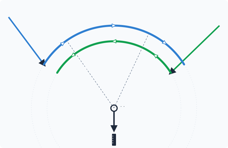
- Merge point (M): where all flows join. From there it is a single route to the IAF.
- Sequencing arcs: curved legs where the aircraft flies level, always at the same distance from M. So when an aircraft on the arc gets "direct M", its remaining track is always the same, and the spacing only depends on when it leaves.
- Different levels: each flow has its own arc, at its own level, and the arcs are flown in opposite directions. The two flows stay vertically separated until they leave the arc.
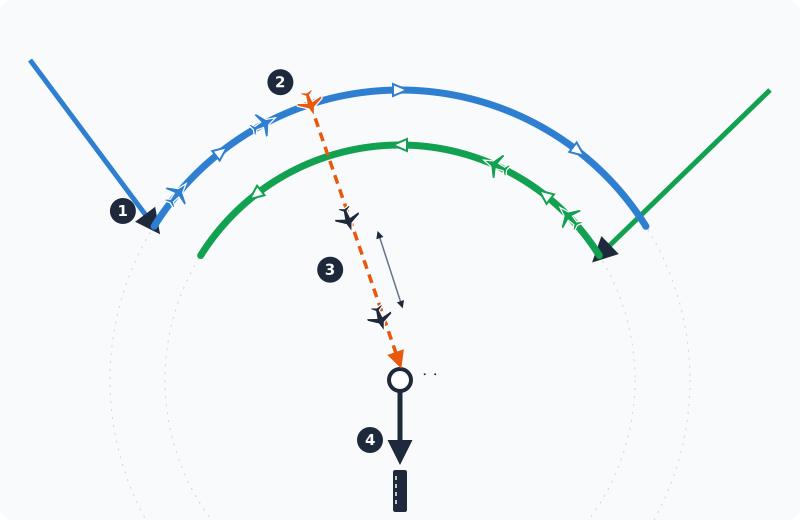
- The aircraft joins the arc and flies level, at the chart speed.
- Once the aircraft ahead is far enough, the controller clears direct M and the descent. The point where it leaves the arc sets the spacing.
- They all fly the same track to M, one behind the other. The spacing is the separation minimum or the wake minimum, whichever is greater.
- From M, the aircraft follows the STAR to the IAF and the approach.
When to use it: only with heavy traffic. With the arc, every arrival flies further than on the direct STAR, so in normal traffic it only adds delay. Day to day, use the direct arrivals.
Benefits at the peak: fewer vectors and fewer transmissions, a continuous descent from the arc exit and predictable tracks for everyone. If the arc ends without an instruction, the aircraft follows the STAR to M (on the SBGR charts, the end of the arc already leads to the merge point). If demand exceeds the capacity of the arcs, use holding.
Using point merge
- With heavy traffic, clear the STAR with the arc and let the aircraft continue at the arc level.
- When the spacing to the aircraft ahead is enough (see wake turbulence), clear direct to the merge point and the descent.
- From there, the aircraft follows the STAR to the IAF; vector to final if you need to adjust.
Most used approaches
The normal approach procedure (IAC) for each runway, the RNP alternative and the special-use procedures. The IAF is where the STAR ends; the approach starts there.
| Runway | Standard | IAF | RNP alternative | Other |
|---|---|---|---|---|
| 10R | ILS Y (segregated operations) | LOMEN | RNP Y | Without segregated operations: ILS Q or RNP X (alternates). Low visibility: ILS Q CAT II & III. Without GNSS: ILS P or LOC P (radar required). ILS R: from GR283, requires RF |
| 28L | ILS Y (segregated operations) | UTKUG | RNP Z | Without segregated operations: ILS W or RNP X (alternates). Without GNSS: ILS Z or LOC Z (radar required) |
| 10L | ILS O or ILS W (CAT I and II) | LOMEN | RNP T or RNP W | Without GNSS: ILS N or LOC N. RNP S (AR): special authorization |
| 28R | ILS T or ILS M | UTKUG | RNP V or RNP M | Without GNSS: ILS W or LOC W (DME arc) |
10R and 28L are the landing runways. Apply segregated operations whenever possible: on both runways ILS Y is the standard (on 10R, with higher minima and an immediate right turn on the missed approach); ILS Q (10R) and ILS W (28L) are the alternates. 10L and 28R only take landings outside normal operations (see SBGR). There is no CAT II or III on 28L and 28R.
| Runway | Standard | IAF | RNP alternative | Other |
|---|---|---|---|---|
| 17R | ILS X | LUVDI, KOMGU | RNP Y | Without GNSS: ILS Y or LOC Y (via STN and AKRUB). RNP X (AR): special authorization |
| 17L | RNP T (CAT A, B and C only) | LUVDI, KOMGU | — | VOR Z (17L and 17R) |
| 35L | ILS V | ESUNI, OGTAL | RNP Z | Without GNSS: ILS R or LOC R. RNP X (AR): special authorization |
| 35R | RNP S (CAT A, B and C only) | ESUNI, OGTAL | — | VOR Y (35L and 35R) |
| Runway | Standard | IAF | RNP alternative | Other |
|---|---|---|---|---|
| 15 | ILS Z | ITEDI, NOBRE, NILKA | RNP Z | Without GNSS: ILS X or LOC X (from MUPIP, missed approach with vectors). VOR Z. RNP Y (AR): special authorization |
| 33 | RNP X (no ILS) | KP209, KP191, UBKUP | — | VOR Y. RNP W (AR): special authorization |
| Runway | Standard | IAF | RNP alternative | Other |
|---|---|---|---|---|
| 16 | ILS T | SJ063, LONES | RNP W | Without GNSS: ILS V or LOC V (DME arc), VOR Z. RNP Z (AR): special authorization. VOR Y: military aircraft only |
| 34 | RNP X (no ILS) | DAGOV, SOTPI | — | VOR |
| Aerodrome | Runway | Standard | Other |
|---|---|---|---|
| SBJD | 18 | RNP Z (CAT A, B and C) | RNP A: circling via a prescribed visual track. No IAC for 36 |
| SDCO | 01 | RNP Z (CAT A, B and C) | High minima: 1000 ft and 5000 m |
| SDCO | 19 | RNP Y (CAT A, B and C) | High minima: 1000 ft and 5000 m |
| SBST | 35 | RNP Z (CAT A, B and C) | Helicopters: RNP 076 (point in space, continue VFR from UDUSU). No IAC for 17 |
| SBTA | 08 / 26 | RNP (helicopters only, CAT H) | VOR 08, VOR 26, RNP Z and VOR Z 26: helicopters only too. No fixed-wing IFR approach |
SBMT has no instrument approach procedure.
- AR (Authorization Required): RNP AR requires special approval of the aircraft and crew. Only clear it if the pilot asks for it.
- Without GNSS: the conventional versions use VOR and DME, for aircraft that can't fly RNAV.
Source: each aerodrome's IAC charts on AISWEB (AIRAC 2209A1 to 2609A1). The charts don't say which procedure is the standard; the criterion used here is a CAT I ILS from the IAF where the STAR ends, or RNP where there is no ILS. Exception: on SBGR 10R and 28L, the standard is the segregated-operations ILS Y.
Departures
SIDs also change often and aren't listed here. Check the current chart in the Aeronautical Charts tab.
- All SIDs are RNAV 1, except each aerodrome's OMNI. The OMNI is used when the aircraft can't fly the RNAV SID, or at ATC discretion5. On it the aircraft climbs on the assigned heading to the chart altitude and awaits instructions: vector it as soon as it calls.
- The SID depends on the runway in use and the exit fix in the flight plan.
- RNAV SIDs publish no initial level: the vertical limit is set by the fix restrictions.
- Pilots who can't meet the SID altitude restrictions tell ATC before take-off2.
- Climb departures to their cruising level whenever possible: release the climb above the SID restrictions as soon as there is no conflict, especially with arrivals crossing above.
Next unit by departure direction:
- North and northeast: Brasília ACC.
- West, southwest and south: Curitiba ACC.
- East: Rio de Janeiro APP (SBWJ) or Brasília ACC, depending on the fix.
TMA circulation
TMA STARs and SIDs cross at several points. The charts separate most of these crossings vertically: the arrival passes above or below the departure thanks to the level restrictions. That separation depends on both aircraft meeting the restrictions. With a direct, a vector or a cancelled restriction, it can disappear.
The maps below show arrivals (solid line) and departures (dashed) in the two most common configurations, with the potential conflict points: crossings where the levels predicted by the charts are less than 4000 ft apart.
- Red: less than 2000 ft. The chart's vertical separation is small; treat it as a conflict.
- Orange: 2000 to 4000 ft. Separated by the chart, but the margin goes away with a direct or a released climb.
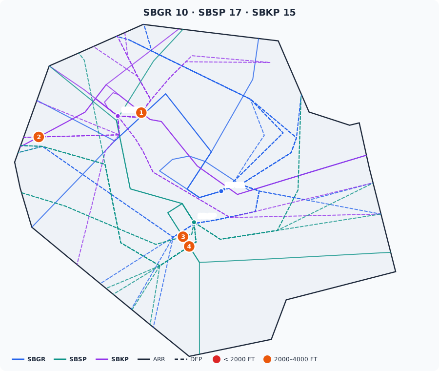
| Point | Arrival | Departure | Predicted level (arrival / departure) |
|---|---|---|---|
| 1 | SBKP EDMUS 1B | SBKP EGBEN 1A, ISMOB 1A, KONVI 2C | FL100 / 6500 FT |
| 2 | SBKP VERME 1A | SBKP EGEVA 1A | FL110 / 8500 FT |
| 3 | SBSP OGTAL 2A | SBSP UBRAM 1A | 9000 FT / 5500 FT |
| 4 | SBSP OGTAL 2A | SBSP UGTIX 2A, UTKOM 1A | 9000 FT / 7000 FT |
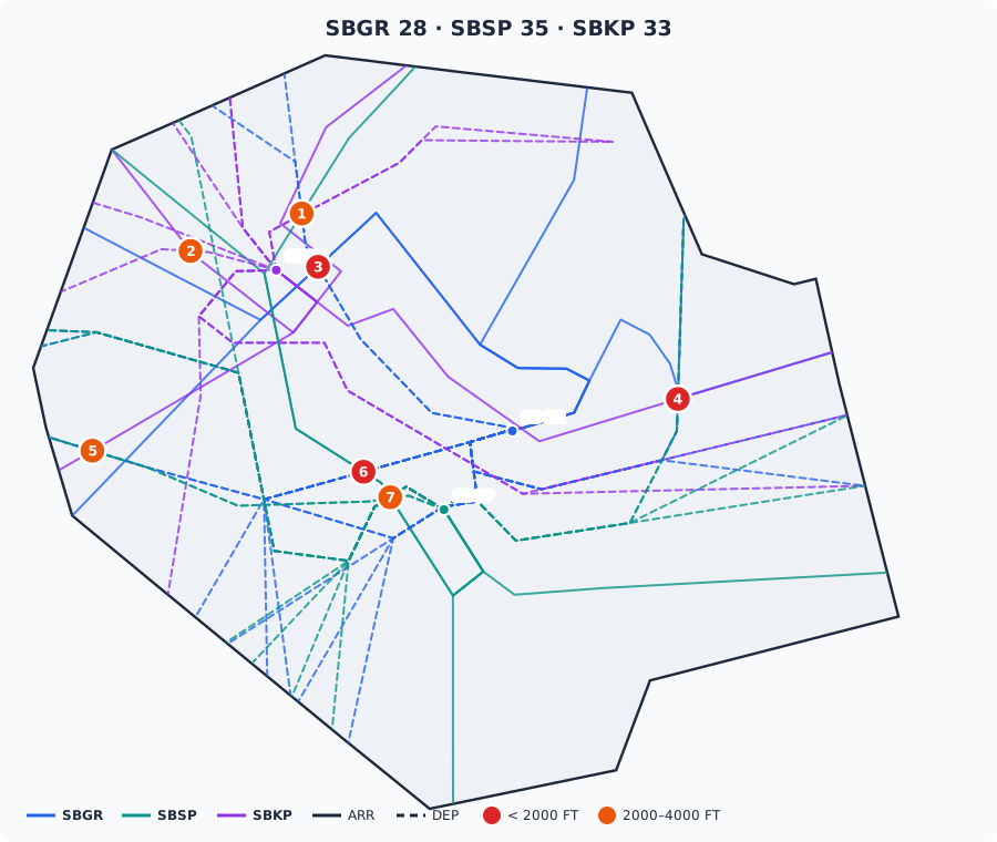
| Point | Arrival | Departure | Predicted level (arrival / departure) |
|---|---|---|---|
| 1 | SBSP ORESU 1B | SBGR XOLUS 1A | FL205 / FL170 |
| 2 | SBKP UBKUP 2A | SBKP EGEVA 1B | FL125 / 8500 FT |
| 3 | SBGR MOLLE 1C | SBGR XOLUS 1A | FL170 / FL160 |
| 4 | SBKP EDMUS 1A | SBGR ISNAP 2A, SBSP BAIAN 3B | FL250 / FL240–FL245 |
| 5 | SBKP UBKUP 2A | SBGR AKRER 3A, SBSP UBRAM 1B | FL135 / FL110 |
| 6 | SBSP ORESU 1B | SBGR AKRER 3A | FL100 / 8500 FT |
| 7 | SBSP ORESU 1B | SBSP SEDLO 1A, UBRAM 1B, UGTIX 1B | 9000 FT / 6500–7000 FT |
At the conflict points
- Before giving a direct or cancelling a restriction to an aircraft passing a marked point, check the traffic on the other flow.
- Prefer to keep the chart restrictions near these points and release the climb or descent after the crossing.
- With split positions, points on the boundary of two sectors call for coordination between them.
How the maps are made: the routes come from the SIDs and STARs in the sector package; the point-merge STARs with arcs are left out, because they aren't used day to day. The predicted level at each crossing is an estimate: the arrival descends at 3° to the threshold and the departure climbs at 500 ft per NM, always held to the chart restrictions (AIRAC 2508A1 to 2610A1). Crossings within 5 NM of the threshold belong to the Tower and aren't shown.
Transfers
General rules are in the Coordination and Transfer Manual. In the São Paulo TMA:
| From | To | When | How the aircraft arrives |
|---|---|---|---|
| ACC | APP | At the TMA boundary, over the STAR entry fix | Cleared on the STAR, at the fix transfer level |
| APP | ACC | Approaching the TMA boundary (lateral or FL245) | On the SID, climbing to cruising level whenever possible |
| APP | Neighbouring APP (Rio, Academia) | At the shared exit fixes | Coordinate the level; SBKP and SBGR STARs and SIDs cross the Academia and Rio TMAs |
| APP | TWR | Established on final, around 8 to 10 NM from the threshold | Separated from the aircraft ahead on final |
| TWR | APP | Right after take-off | On the SID or on the OMNI heading |
| Sector | Final (*_F_APP) | When descending below FL100 near the aerodrome | On the STAR, with the sequence set up |
- At SBGR, the pilot states the departure runway on first contact with São Paulo Control4.
- Aircraft entering the Campinas CTR call the APP on 119.800 or 133.850; for the São José CTR, on 129.0507.
Transfer points and levels
Arrivals to São Paulo APP. The transferring unit clears the descent to the level in the table and hands the aircraft over at the fix; from there, the APP continues the descent along the STAR.
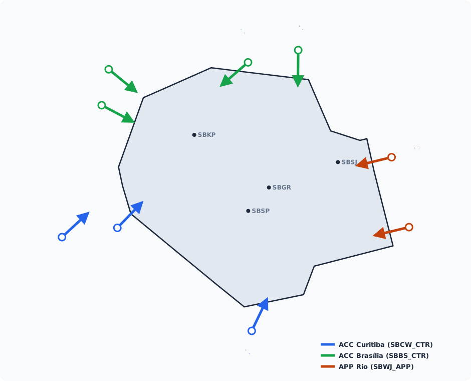
| From | Fix | Destination | Descent cleared to | STAR |
|---|---|---|---|---|
ACC Curitiba (SBCW_CTR) | ANISE | SBSP, SBSJ | FL150 | SBSP OGTAL 2A; SBSJ DAGOV 1A, LONES 1A |
ACC Curitiba (SBCW_CTR) | EDRAT | SBKP | FL140 | UBKUP 2A, VERME 1A |
ACC Curitiba (SBCW_CTR) | BUXUK | SBGR | FL220 | MOLLE 1A, 1B, 1C, 1D |
ACC Brasília (SBBS_CTR) | ZARES | SBGR | FL210 | MOLLE 1A, 1B, 1C, 1D |
ACC Brasília (SBBS_CTR) | VUNOX | SBGR, SBSJ | FL180 | SBGR VUNOX 1A, 1B, 1C, SANPA 1A; SBSJ LONES 1A |
ACC Brasília (SBBS_CTR) | UTLOT | SBKP | FL140 | UTLOT 3A, UBKUP 2A |
ACC Brasília (SBBS_CTR) | UTLOT | SBSP | FL210 | ORESU 1A, 1B |
ACC Brasília (SBBS_CTR) | ENTIT | SBKP | FL150 | ENTIT 1A, ITEDI 1A |
ACC Brasília (SBBS_CTR) | ENTIT | SBSP | FL220 | ORESU 1A, 1B |
APP Rio (SBWJ_APP) | EDMUS | SBGR | FL110 | EDMUS 1B, 2A |
APP Rio (SBWJ_APP) | EDMUS | SBKP | FL240 | EDMUS 1A, 1B, ITEDI 1A |
APP Rio (SBWJ_APP) | IBDAL | SBSP | FL110 | IBDAL 2A, OGTAL 2A |
Departures have no transfer level: the APP climbs the aircraft to its cruising level whenever possible and hands it over as it approaches the TMA boundary.
Departure directs
To speed up the flow, the APP may clear a direct to the fixes below, even though they lie outside the São Paulo TMA. The aircraft leaves the SID, flies direct to the fix and is handed over to the unit in the table as it approaches the TMA boundary.
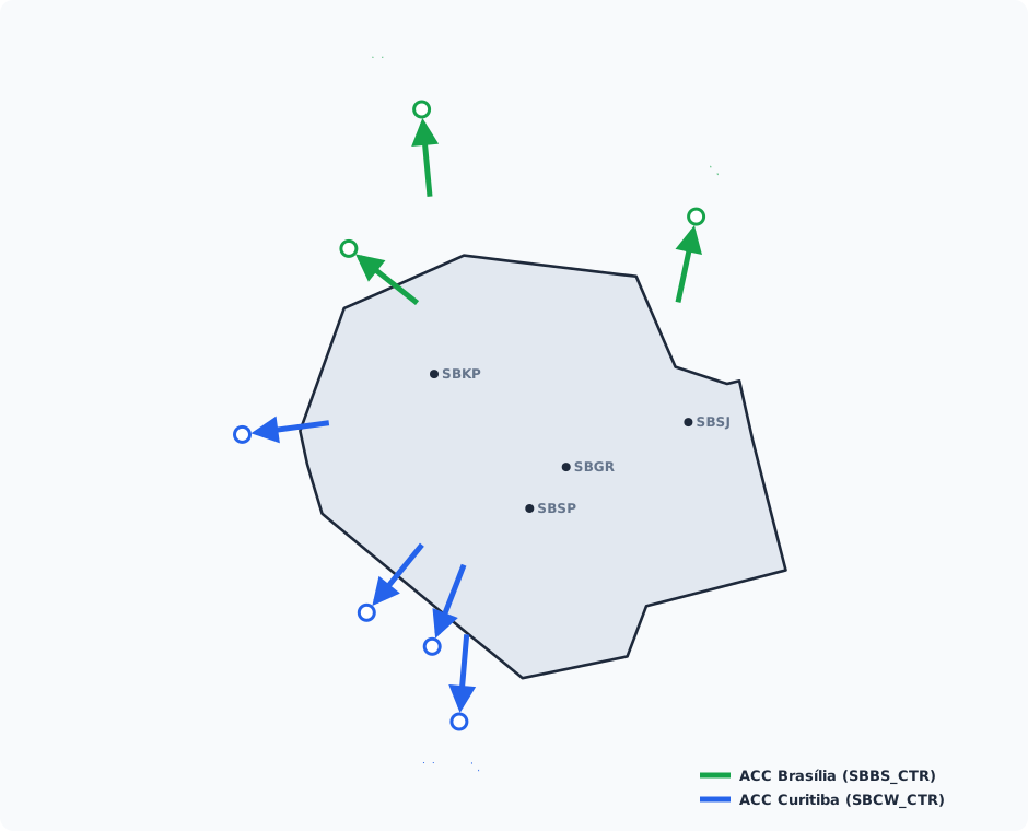
| To | Fix | Origin | SID |
|---|---|---|---|
ACC Brasília (SBBS_CTR) | NUXEL | SBGR, SBSP, SBSJ | SBGR AMVUL 6A, EVNEB 3A, ISNAP 2A, REORI 3A; SBSP BAIAN 3A, 3B; SBSJ BOBIC 3A, VUSMA 3A |
ACC Brasília (SBBS_CTR) | ISMOB | SBGR, SBKP | SBGR AMVUL 6A, ORONU 1A, REORI 3A, XOLUS 1A; SBKP EGBEN 1A, ISMOB 1A, OPGUN 2A |
ACC Brasília (SBBS_CTR) | GERTU | SBGR, SBSP, SBKP | SBGR AMVUL 6A, ORONU 1A, REORI 3A, XOLUS 1A; SBSP UGTIX 1B, 2A; SBKP EGBEN 1A, OPGUN 2A |
ACC Curitiba (SBCW_CTR) | ASETA | SBGR, SBSP, SBKP | SBGR AKRER 3A, CGO 4B, 5A, ZORZA 3A, 5B; SBSP UBRAM 1A, 1B, UGTIX 1B, 2A; SBKP ASETA 1A, OSUDO 4A |
ACC Curitiba (SBCW_CTR) | SOVSI | SBGR, SBSP, SBKP | SBGR AKRER 3A, CGO 4B, 5A, ZORZA 3A, 5B; SBSP SEDLO 1A, UTKOM 1A; SBKP OSUDO 4A, SOVSI 1A |
ACC Curitiba (SBCW_CTR) | UBSOD | SBGR, SBSP | SBGR AKRER 3A, CGO 4B, 5A, ZORZA 3A, 5B; SBSP SEDLO 1A, UTKOM 1A |
ACC Curitiba (SBCW_CTR) | MADNI | SBGR, SBSP | SBGR AKRER 3A, CGO 4B, 5A, ZORZA 3A, 5B; SBSP SEDLO 1A, UTKOM 1A |
- Only give the direct when the fix is in the aircraft's flight plan.
- Before the direct, check the conflict points with arrivals: the direct takes the aircraft off the SID restrictions.
Speeds and separation
| Situation | Value |
|---|---|
| Below FL100 | 250 kt maximum |
| SBGR point-merge arcs | 250 kt |
| SANPA | 230 kt |
| SBGR final | 180 kt at 10 NM and 160 kt at 5 NM from the threshold4 |
| Radar separation | 5 NM or 1000 ft; 3 NM on SBGR final4 |
| VFR helicopter × IFR on SBSP final 17 / departure 35 | Composite separation 2.5 NM × 500 ft8 |
Special procedures
- Visual approach at SBSP: with visibility ≥ 5 km and ceiling ≥ 1000 ft, the APP may vector for a visual approach. The flight plan stays IFR until the pilot reports the runway in sight6.
- Aircraft without RNAV at SBGR, SBSP and SBKP: with the conventional navaids out, it may arrive visually. The pilot states on first contact the intention to change from IFR to VFR and requests the change near the aerodrome5.
- Missed approach off the profile at SBKP with communication failure: climb to 6000 ft and fly to the IAF of the procedure in use7.
TMA São Paulo 2 and VFR circulation
Visual navigation documents
- Circular: AIC N 29/26 – Circulação VFR Integrada na TMA-SP e Vale do Paraíba
- Circular: AIC N 15/16 – Regras de Apresentação de Plano de Voo para Voos VFR dentro dos limites laterais da TMA-SP e TMA-RJ (effective 13 OCT 2016)
- Visual chart – Aircraft routes (REA): CCV REA XP2-São Paulo
- Visual chart – Aircraft routes (REA): CCV REA XP1-São Paulo
- Visual chart – Helicopter routes (REH): CCV REH XP2-São Paulo 1
- Visual chart – Helicopter routes (REH): CCV REH XP2-São Paulo 2
- Visual chart – Helicopter routes (REH): CCV REH XP2-Campinas
- Visual chart – Helicopter routes (REH): CCV REH XP1-São José dos Campos
- Visual chart – Helicopter routes (REH): CCV REH XP1-Sorocaba
The charts are embedded in the Visual Charts tab under Useful Information. The TMA São Paulo 2 chart is CCV REA XP2-São Paulo. The data in this section comes from AIC N 29/269.
TMA São Paulo 2 (Visual sector)
TMA São Paulo is split into two layers9. São Paulo 1 is the IFR airspace, above 5500 ft. São Paulo 2 is a low layer over the metropolitan area, on top of the Campinas, Jundiaí, Congonhas, Guarulhos and Marte CTRs and the Marte ATZ. It exists, in essence, for visual flights: VFR traffic crosses the area along corridors (REA) whose maximum altitudes keep it below the IFR flows.
| Limits | Above 3600 ft up to 5500 ft (inclusive) |
| Class | C |
| Position | SBXP_V_APP (Visual sector; in the real world, APP-SP sector T-14) |
| Callsign | São Paulo Control |
| Frequency | 129.500 MHz1 |
| Speed | 200 kt IAS maximum |
| Coverage | With SBXP_V_APP closed, SBXP_APP takes the layer (see coverage) |
- In the package, SBMT and SBJD departures and arrivals belong to the Visual sector.
- The same 129.500 provides flight information and alerting on request in the class G airspace below the TMA, and gives the QNH to anyone who can't receive an ATIS.
- In class C, the APP separates IFR from IFR and IFR from VFR. Between two VFR flights, it gives traffic information.
- The SBGR and SBSP finals and departures below 5500 ft cross the layer. The corridor maximum altitudes protect these flights: a VFR outside its corridor or above the maximum is a conflict with IFR.
- The layer above, São Paulo 1, is class C up to FL145: VFR traffic enters it only with a clearance.
- In the Paraíba valley (outside the TMA), the REAs cross the São José, Taubaté and Guaratinguetá CTRs. In the real world, the controlled segments there use APP-SP on 134.150 / 124.150, Taubaté Tower (119.900) and Guaratinguetá APP (120.150). On the network, pilots call whichever position is online: turn on the APP sectors layer on the map to see who covers the segment.
General VFR rules
- Mandatory corridors: VFR traffic flies the published routes, at the published tracks and altitudes, unless ATS instructs or clears otherwise, in TMA São Paulo 2, in the CTRs, in the ATZs of controlled aerodromes, in the FIZs below the TMA and on these REA segments:
- CHARLIE, CERQUILHO to PEDÁGIO CASTELO; DELTA, TREVO to PERUS; ECHO, PERUS to DOM PEDRO; all of KILO;
- LIMA, CABREÚVA to CAMBUÍ; all of NOVEMBER; OSCAR, TAPIRAÍ to FURNAS and VARGEM GRANDE to PERUS; PAPA, ITAPEVI to RÉGIS;
- QUEBEC, PARQUE DO CARMO to PALMEIRAS; ROMEO, REPRESA SUZANO to ITAQUERA; SIERRA, INTERLIGAÇÃO to PALMEIRAS;
- FOXTROT, TRAVÉS ÁGUIA to BERTIOGA; MIKE, TRAVÉS NORTE IGARATÁ to CACHOEIRA; TANGO, PARAIBUNA to REDENÇÃO; UNIFORM, CAÇAPAVA to REDENÇÃO.
- Keep right: aircraft fly to the right of the corridor centreline. Where the circular requires it, they fly the centreline or overfly the point (fly over), as at PEDÁGIO CASTELO and ANHANGUERA on NOVEMBER.
- The maximum altitude separates VFR from the IFR traffic above: in controlled airspace it is mandatory. The minimum altitude is the obstacle clearance altitude of the segment; below it, the pilot is responsible.
- Class G: outside controlled airspace, VFR traffic stays at 5000 ft maximum, because of the IFR network above, except on corridor segments that publish a different altitude. On CHARLIE, LIMA and OSCAR, anyone wanting to climb above 5000 ft must follow the corridor, and heading changes only at 5000 ft or below.
- Descent: in controlled airspace, plan to be at the maximum altitude from the position where it starts to apply.
- CTRs, ATZs and FIZs: enter and leave through the gates, unless ATC instructs otherwise. Call the unit before entering.
- Speed: 200 kt IAS maximum in controlled airspace; 160 kt recommended at the Marte gates.
- Reporting: when crossing a reporting position, report on the ATC frequency or on the FCA of that segment.
- Crossing IFR tracks: VFR traffic does not cross IFR departures and arrivals at a conflicting altitude without an ATS clearance.
- Transponder on (mode A/C or S) in the whole area, class G included.
- Flights from outside controlled airspace entering the TMA via the REA or REH corridors are exempt from filing a flight plan, but must first report registration, position, persons on board, endurance, origin and destination.
Visual corridors (REA)
Altitudes in feet (QNH), as maximum / minimum. Where altitudes depend on the direction, each track has its own. ⇄ is two-way; → is one-way. Segments marked D · APP-SP 129.500 belong to the Visual sector. Corridors are 3 NM wide (1.5 NM each side of the centreline).
Metropolitan area (corridors that cross TMA São Paulo 2):
| REA | Segment | Tracks | Altitudes (max. / min.) | Airspace · contact |
|---|---|---|---|---|
| CHARLIE | CERQUILHO ⇄ PORTO FELIZ ⇄ RONDON | 126° / 306° | 126°: 6500 / 5000 · 306°: 5000 / 4500 | G · FCA Norte 135.675 |
| RONDON ⇄ ITU | 126° / 306° | 5000 / 3200 | G · FCA Norte 135.675 | |
| ITU ⇄ CABREÚVA | 126° / 306° | 5000 / 4800 | G · FCA Norte 135.675 | |
| CABREÚVA ⇄ SANTANA | 147° / 327° | 147°: 5000 / 4500 · 327°: 4800 / 4500 | D · APP-SP 129.500 | |
| PEDÁGIO CASTELO → SANTANA | 306° | 4500 / 4000 | D · APP-SP 129.500 | |
| DELTA | TREVO → PEDÁGIO LEROY | 169° | 4500 | D · APP-SP 129.500 |
| PEDÁGIO LEROY ⇄ PERUS | 169° / 349° | 169°: 4300 / 4100 · 349°: 4100 | D · APP-SP 129.500 | |
| ECHO | PERUS → MORATO | 023° | 4200 / 4000 | D · APP-SP 129.500 |
| MORATO ⇄ TRAVÉS JARINU ⇄ DOM PEDRO | 015° / 195° | 4500 / 4000 | D · APP-SP 129.500 | |
| DOM PEDRO ⇄ MORUNGABA | 015° / 195° | 015°: 5000 / 4300 · 195°: 4500 / 4300 | G · FCA Norte 135.675 | |
| MORUNGABA ⇄ TRAVÉS AMPARO | 040° / 220° | 040°: 5000 / 4300 · 220°: 4700 / 4300 | G · FCA Norte 135.675 | |
| TRAVÉS AMPARO ⇄ SERRA NEGRA ⇄ LINDÓIA | 039° / 219° | 039°: 5500 / 5000 · 219°: 6000 / 5000 | G · FCA Norte 135.675 | |
| KILO | TRAVÉS JARINU ⇄ ATIBAIA | 102° / 282° | 4500 / 4100 | D · APP-SP 129.500 |
| LIMA | CABREÚVA ⇄ PEDÁGIO LEROY | 115° / 295° | 5000 / 4800 | D · APP-SP 129.500 |
| PEDÁGIO LEROY ⇄ MORATO ⇄ ATIBAIA | 068° / 248° | 4500 / 4100 | D · APP-SP 129.500 | |
| ATIBAIA ⇄ JOANÓPOLIS | 079° / 259° | 079°: 6000 / 5000 · 259°: 5500 / 5000 | G · FCA Norte 135.675 | |
| JOANÓPOLIS ⇄ CAMANDUCAIA ⇄ CAMBUÍ | 056° / 236° | 056°: 8000 / 6000 · 236°: 7500 / 6000 | G · FCA Norte 135.675 | |
| NOVEMBER | ANHANGUERA → PEDÁGIO CASTELO → ITAPEVI | 276° | 3700 / 3600, then 3700 | D · APP-SP 129.500 |
| OSCAR | TAPIRAÍ ⇄ FURNAS | 073° / 253° | 6000 / 5000 | G · FCA Sul 126.650 |
| FURNAS ⇄ VARGEM GRANDE | 073° / 253° | 073°: 4500 / 4000 · 253°: 5000 / 4000 | G · FCA Sul 126.650 | |
| VARGEM GRANDE ⇄ ITAPEVI | 073° / 253° | 073°: 4500 / 4000 · 253°: 5000 / 4000 | D · APP-SP 129.500 | |
| ITAPEVI ⇄ SANTANA | 029° / 209° | 4500 / 4200 | D · APP-SP 129.500 | |
| SANTANA → PERUS | 104° | 4300 / 4100 | D · APP-SP 129.500 | |
| PAPA | ITAPEVI ⇄ RÉGIS | 181° / 001° | 4500 / 4000 | D · APP-SP 129.500 |
| RÉGIS ⇄ EMBU-GUAÇU | 181° / 001° | 4500 / 4000 | G · FCA Sul 126.650 | |
| EMBU-GUAÇU ⇄ ITANHAÉM | 198° / 018° | 198°: 5000 / 3500 · 018°: 4500 / 3500 | G · FCA Sul 126.650 | |
| QUEBEC | PARQUE DO CARMO ⇄ RODOANEL SUL | 130° / 310° | 130°: 5000 / 4100 · 310°: 4100 (only with SBMT on 12) | D · APP-SP 129.500 |
| RODOANEL SUL → PALMEIRAS → MOGI BERTIOGA | 113° | 5000 / 4100 | D · APP-SP 129.500 | |
| MOGI BERTIOGA → REPRESA RIBEIRÃO | — | 5000 / 4700 | G · FCA Litoral 122.925 | |
| REPRESA RIBEIRÃO → USINA CARAGUÁ | — | 7500 / 4700 | G · FCA Litoral 122.925 | |
| ROMEO | ILHA ANCHIETA → REPRESA PARAIBUNA | 291° | 7000 / 4400 | G · FCA Litoral 122.925 |
| REPRESA PARAIBUNA → SALESÓPOLIS | — | 6000 / 4600 | G · FCA Sul 126.650 | |
| SALESÓPOLIS → REPRESA SUZANO | 282° | 5000 / 4100 | D · APP-SP 129.500 | |
| REPRESA SUZANO → RODOANEL NORTE | 304° | 5000 / 3700 | D · APP-SP 129.500 | |
| RODOANEL NORTE → ITAQUERA | 309° | 4000 / 3700 | D · APP-SP 129.500 | |
| SIERRA | ITANHAÉM ⇄ INTERLIGAÇÃO | 056° / 236° | 5000 / 4000 | G · FCA Sul 126.650 |
| INTERLIGAÇÃO ⇄ RIO GRANDE | 064° / 244° | 4300 / 4000 | G · FCA Sul 126.650 | |
| RIO GRANDE ⇄ PALMEIRAS | 064° / 244° | 4300 / 4000 | D · APP-SP 129.500 | |
| PALMEIRAS ⇄ REPRESA SUZANO | 063° / 243° | 063°: 5000 / 4000 · 243°: 4500 / 4000 | D · APP-SP 129.500 | |
| REPRESA SUZANO ⇄ GUARAREMA | 070° / 250° | 070°: 5000 / 4000 · 250°: 4500 / 4000 | D · APP-SP 129.500 |
Inland, coast and Paraíba valley:
| REA | Segment | Tracks | Altitudes (max. / min.) | Airspace · contact |
|---|---|---|---|---|
| ALFA | TRAVÉS AMERICANA ⇄ CAPIVARI | 228° / 048° | 228°: 4000 / 3200 · 048°: 4500 / 3200 | G · FCA Norte 135.675 |
| CAPIVARI ⇄ RONDON ⇄ ÉDEN ⇄ TOBIAS | 189° / 009° | 4000 / 3200 | G · FCA Norte 135.675 | |
| TOBIAS ⇄ REPRESA ALUMÍNIO | 142° / 322° | 4500 / 4100 | G · FCA Norte 135.675 | |
| REPRESA ALUMÍNIO ⇄ FURNAS | 142° / 322° | 5000 / 4100 | G · FCA Norte 135.675 | |
| FURNAS ⇄ EMBU-GUAÇU | 142° / 322° | 4500 / 4300 | G · FCA Sul 126.650 | |
| EMBU-GUAÇU ⇄ INTERLIGAÇÃO | 127° / 307° | 4500 / 4100 | G · FCA Sul 126.650 | |
| BRAVO | LIMEIRA ⇄ COSMÓPOLIS ⇄ JAGUARIÚNA | 131° / 311° | 131°: 4500 / 3200 · 311°: 5000 / 3200 | G · FCA Norte 135.675 |
| JAGUARIÚNA ⇄ MORUNGABA ⇄ ATIBAIA | 157° / 337° | 157°: 4500 / 4400 · 337°: 5000 / 4400 | G · FCA Norte 135.675 | |
| ATIBAIA ⇄ IGARATÁ | 127° / 307° | 127°: 5000 / 4900 · 307°: 4900 / 4900 | G · FCA Norte 135.675 | |
| IGARATÁ ⇄ GUARAREMA ⇄ SALESÓPOLIS | 173° and 145° / 325° and 353° | Outbound: 5000 / 3500 · inbound: 4500 / 3500 | G · FCA Sul 126.650 | |
| SALESÓPOLIS ⇄ REPRESA RIBEIRÃO | 192° / 012° | 192°: 5500 / 4600 · 012°: 5000 / 4600 | G · FCA Litoral 122.925 | |
| FOXTROT | ITANHAÉM ⇄ TRAVÉS ÁGUIA | 082° / 262° | 082°: 5000 / 2500 · 262°: 5500 / 2500 | G · FCA Sul 126.650 |
| TRAVÉS ÁGUIA ⇄ BERTIOGA | 085° / 265° | 085°: 5500 / 2500 · 265°: 5000 / 2500 | G · Rádio Santos 118.650 | |
| BERTIOGA ⇄ RIVIERA | 091° / 271° | 091°: 6000 / 2000 · 271°: 5500 / 2000 | G · FCA Litoral 122.925 | |
| RIVIERA ⇄ BARRA DO UNA | 091° / 271° | 091°: 6500 / 2000 · 271°: 6000 / 2000 | G · FCA Litoral 122.925 | |
| BARRA DO UNA ⇄ USINA CARAGUÁ | 091° / 271° | 091°: 6500 / 4000 · 271°: 6000 / 4000 | G · FCA Litoral 122.925 | |
| USINA CARAGUÁ ⇄ ILHA ANCHIETA ⇄ LARANJEIRAS | 091° / 271° | Eastbound: FL095 / 4000 · westbound: FL085 / 4000 | G · FCA Litoral 122.925 | |
| LARANJEIRAS ⇄ PONTA | 091° / 271° | 091°: 6500 / 3000 · 271°: FL085 / 3000 | G · FCA Litoral 122.925 | |
| GOLF | ROSEIRA ⇄ SUL BASÍLICA | 139° / 319° | 139°: 6500 / 5200 · 319°: 5500 / 5200 | D · APP-GW 120.150 |
| SUL BASÍLICA ⇄ CUNHA | 139° / 319° | 139°: 6500 / 5200 · 319°: 5500 / 5200 | G · FCA Litoral 122.925 | |
| CUNHA ⇄ BAÍA | 126° / 306° | 126°: 6500 / 6200 · 306°: 6200 | G · FCA Oeste 134.450 | |
| HOTEL | ITU ⇄ CAPIVARI | 347° / 167° | 347°: 5000 / 3200 · 167°: 4500 / 3200 | G · FCA Norte 135.675 |
| CAPIVARI ⇄ PEDRAS | 359° / 179° | 359°: 5000 / 3200 · 179°: 4500 / 3200 | G · FCA Norte 135.675 | |
| INDIA | PIRACICABA ⇄ TRAVÉS AMERICANA ⇄ COSMÓPOLIS | 098° / 278° | 098°: 4500 / 3000 · 278°: 5000 / 3000 | G · FCA Norte 135.675 |
| MIKE | ATIBAIA ⇄ TRAVÉS NORTE IGARATÁ | 115° / 295° | 5000 / 4600 | G · FCA Norte 135.675 |
| TRAVÉS NORTE IGARATÁ ⇄ TRAVÉS NORTE SÃO JOSÉ | 101° / 281° | 4000 / 3800 | D · APP-SP 134.150 | |
| TRAVÉS NORTE SÃO JOSÉ ⇄ CAÇAPAVA | 116° / 296° | 4000 / 3500 | D · APP-SP 134.150 | |
| CAÇAPAVA ⇄ TREVO CARVALHO PINTO ⇄ TAUBATÉ | 082° / 262° | 082°: 5500 / 3500 · 262°: 4500 / 3500 | D · TWR-TA 119.900 | |
| TAUBATÉ ⇄ PEDÁGIO DUTRA | 082° / 262° | 082°: 5500 / 3500 · 262°: 5000 / 3500 | D · TWR-TA 119.900 | |
| PEDÁGIO DUTRA ⇄ ROSEIRA | 082° / 262° | 082°: 5500 / 3500 · 262°: 5000 / 3500 | D · APP-GW 120.150 | |
| ROSEIRA ⇄ BASÍLICA | 075° / 255° | 075°: 5500 / 4100 · 255°: 5000 / 4100 | D · APP-GW 120.150 | |
| BASÍLICA ⇄ FÁBRICA DUTRA | 071° / 251° | 5500 / 3500 | D · APP-GW 120.150 | |
| FÁBRICA DUTRA ⇄ CACHOEIRA | 071° / 251° | 5500 / 3100 | D · APP-GW 120.150 | |
| SOROCABA 01 | PORTO ⇄ LAGO | 097° / 277° | 4500 / 3100 | G · FIZ Sorocaba 118.800 |
| SOROCABA 02 | SARAPUÍ ⇄ HOSPITAL | 089° / 269° | 4500 / 3100 | G · FIZ Sorocaba 118.800 |
| TANGO | SALESÓPOLIS ⇄ PARAIBUNA ⇄ REDENÇÃO | 071° / 251° | 4300 / 4100 | G · FCA Sul 126.650 |
| UNIFORM | CAÇAPAVA ⇄ REDENÇÃO | 158° / 338° | 158°: 5000 / 4800 · 338°: 4900 / 4800 | D · TWR-TA 119.900 |
| REDENÇÃO ⇄ ILHA ANCHIETA | 145° / 325° | 145°: 5500 / 4800 · 325°: 5300 / 4800 | G · FCA Litoral 122.925 |
What each corridor does and where the traps are:
- Entering and leaving TMA São Paulo 2: via the points on its lateral limit (DOM PEDRO, ATIBAIA, CABREÚVA, VARGEM GRANDE, RÉGIS and PALMEIRAS), plus TREVO (Jundiaí CTR) and the one-way pair to the east.
- CHARLIE is the western axis: from Cerquilho via Porto Feliz and Itu to CABREÚVA, and on to SANTANA. From CABREÚVA, the APP picks the route to Marte according to the sequence: CHARLIE and OSCAR (SANTANA, PERUS) or LIMA and DELTA (PEDÁGIO LEROY, PERUS). PEDÁGIO CASTELO → SANTANA is one-way. Helicopter routes run below, at 3200 ft.
- DELTA runs from TREVO (Jundiaí) down to PERUS, at the entrance to Marte. See the Marte gates.
- ECHO is the northern axis: PERUS → MORATO (one-way), then MORATO, TRAVÉS JARINU and DOM PEDRO, up to Amparo, Serra Negra and Lindóia. North of DOM PEDRO it is the mandatory route to enter or leave the TMA on that side, with restricted areas on both sides.
- KILO links TRAVÉS JARINU to ATIBAIA. LIMA links CABREÚVA to PEDÁGIO LEROY, MORATO and ATIBAIA (aircraft at similar altitudes on the segment, terrain up to 4000 ft), then continues to Joanópolis and Cambuí, climbing to 8000 ft.
- NOVEMBER is one-way westbound: ANHANGUERA → PEDÁGIO CASTELO → ITAPEVI, at 3700 ft, with mandatory overflight of ANHANGUERA and PEDÁGIO CASTELO because of the SBSP IFR procedures. The APP may reverse it when needed.
- OSCAR comes from the south-west (Tapiraí, Ibiúna) via VARGEM GRANDE and ITAPEVI to SANTANA; SANTANA → PERUS is one-way.
- PAPA links ITAPEVI and RÉGIS to the south coast (Embu-Guaçu, Itanhaém). Watch the SDIM (Itanhaém) circuit, up to 1500 ft.
- QUEBEC (eastbound exit) and ROMEO (eastern entry) form a one-way pair between the east side of the city and the north coast. ROMEO is the way in from Rio: traffic entering by it, at its altitudes, doesn't need to call the APP before entering São Paulo 1.
- SIERRA crosses the SBSP RWY 35 final from the south, from Itanhaém via Rio Grande da Serra, PALMEIRAS and REPRESA SUZANO to Guararema. It is mandatory for that crossing: don't break the maximum or the lateral limits, because of the SBSP and SBST IFR procedures. It crosses ROMEO.
- MIKE is the Paraíba valley axis, along the Via Dutra, from ATIBAIA to CACHOEIRA. Between TREVO CARVALHO PINTO and TAUBATÉ, both ways, aircraft fly over the Via Dutra to stay clear of the SBTA circuit and IFR procedures. Near SBGW, watch the procedure base turns and the RWY 02 final.
- TANGO and UNIFORM are the southern links to the valley: TANGO passes close to the SBSJ RWY 33 final (don't break the maximum or the northern limit); UNIFORM is the mandatory southern access to MIKE, between SBTA and SBSJ, with a military restricted area to the east.
- FOXTROT is the coastal corridor, from Itanhaém via Praia Grande, Bertioga, Caraguatatuba and Ubatuba to Paraty. Between TRAVÉS ÁGUIA and BERTIOGA, Santos Radio (118.650) gives information; there is a hang-glider and paramotor area below, up to 2500 ft.
- GOLF links Roseira, Cunha and Paraty bay. HOTEL and INDIA link Itu, Capivari, Piracicaba and Cosmópolis; ALFA and BRAVO go around the TMA to the west and north. Leaving the TMA towards Piracicaba (PEDRAS, PIRACICABA, LIMEIRA), call Pirassununga APP on 122.400 and check the NOTAMs.
- SOROCABA 01 (PORTO ⇄ LAGO) and SOROCABA 02 (SARAPUÍ ⇄ HOSPITAL) are the western entries to SDCO, in the Sorocaba FIZ (Sorocaba Tower, 118.800).
Aerodrome gates
Entering and leaving CTRs, ATZs and FIZs with gates is always through the gates, unless ATC instructs otherwise.
| Aerodrome | Gates |
|---|---|
| SBMT (Marte) | COMETA, DUTRA, ABRIL, PENTEADO, ESCOLA PM, PEDREIRA (table below) |
| SBJD (Jundiaí) | LAGOA, ESTÁDIO, TREVO; west side via ELÓI, TRAVÉS SUL ITUPEVA, JAPI, JACARÉ and NATURA |
| SBKP (Viracopos) | ANHANGUERA SUL (east) and INDAIATUBA (west), 3600 ft maximum, in direct contact with Campinas Tower |
| SDAM (Amarais) | ARMAZÉM, SHOPPING, ANHANGUERA SUL |
| SBJH (Catarina) | CABREÚVA, MAILASQUI |
| SBBP (Bragança Paulista) | GUARIPOCABA, FERNÃO DIAS (exit), BOCAINA, INSTRUÇÃO (exit for training) |
| SDAI (Americana) | REPRESA, RODOVIÁRIA |
| SDBN (Bonanza) | SALTO, LEITE, MODELO |
| SBST (Santos) | PARANAPIACABA, BERTIOGA, TRAVÉS ÁGUIA, INTERLIGAÇÃO |
| SBSJ (São José dos Campos) | CAÇAPAVA, REDENÇÃO, JACAREÍ, IGARATÁ |
| SBTA (Taubaté) | PEDÁGIO DUTRA, CAÇAPAVA and REDENÇÃO (points on REAs MIKE and UNIFORM) |
| SBGW (Guaratinguetá) | CACHOEIRA, SUL BASÍLICA, PEDÁGIO DUTRA |
| SDCO (Sorocaba) | INDUSTRIAL, RAPOSO (east); LAGO and HOSPITAL (west) |
| SBGR (Guarulhos) | ITAQUERA, military only |
Marte (SBMT). The Visual sector hands over and takes Marte traffic at the gates. Each gate's direction depends on the runway in use:
| SBMT runway | Side | Arrival | Departure | APP ⇄ Marte TWR handover |
|---|---|---|---|---|
| 12 | East | DUTRA | COMETA | Arrival at PARQUE DO CARMO; departure at ITAQUERA |
| 12 | West | PENTEADO | ABRIL | Arrival at PEDREIRA; departure at ESCOLA PM or ANHANGUERA |
| 30 | East | COMETA | DUTRA | Arrival at ITAQUERA; departure at PARQUE DO CARMO |
| 30 | West | ABRIL | PENTEADO | Arrival at ESCOLA PM; departure at PEDREIRA or ANHANGUERA |
- Reversing the flow with the runway in use means crossings under APP control: between QUEBEC and ROMEO on the east side and near ESCOLA PM and PEDREIRA on the west side. Take extra care on the east side with runway 12 and on the west side with 30.
- Runway 12, east side: traffic arriving on ROMEO, after REPRESA SUZANO, descends to 4100 ft and flies to RODOANEL SUL (274°), keeping it on the left, then to the PARQUE DO CARMO gate. Traffic leaving via ITAQUERA climbs to 5000 ft and flies to RODOANEL SUL, keeping it on the left, then to PALMEIRAS. The two cross near RODOANEL SUL.
- Marte CTR: it protects the SBMT IFR procedures and is only active during IFR operations. When active, VFR traffic does not enter it, nor the REA and REH segments inside it (except public safety and SVH, TROV and TREN missions, under Marte Tower control). When inactive, VFR traffic operates normally in the Marte ATZ and the corridors. Activation: broadcast on the ATIS.
- Departing SBMT (RWY 12 towards the ABRIL gate or RWY 30 towards the DUTRA gate), pilots adjust speed, altitude and turn radius to stay inside the Marte CTR, clear of SBSP and of the helicopter control area. If they can't, they tell Marte Tower and follow the REAs on the departure side.
Jundiaí (SBJD). Gates depend on the runway and the side. For departures, Jundiaí Tower gives the flow direction; for arrivals, the APP:
| SBJD runway | Side | Arrival | Departure | Handover |
|---|---|---|---|---|
| 18 | East | ESTÁDIO | TREVO | TRAVÉS JARINU, PEDÁGIO LEROY |
| 18 | West | JACARÉ | JAPI | JACARÉ, JAPI |
| 36 | East | ESTÁDIO | LAGOA or TREVO | TRAVÉS JARINU, PEDÁGIO LEROY |
| 36 | West | JACARÉ | JAPI | JACARÉ, JAPI |
- Western departures: ELÓI → TRAVÉS SUL ITUPEVA → JAPI → ITU, 3600 ft maximum (mandatory, because of the SBJD and SBKP IFR procedures). Jundiaí Tower gives information up to TRAVÉS SUL ITUPEVA.
- Western arrivals: CABREÚVA → JACARÉ → NATURA → ELÓI, 3800 ft maximum (mandatory). Jundiaí Tower gives information from JACARÉ.
- Both legs are on the Visual corridors (REA) map layer, labelled SBJD.
São José dos Campos (SBSJ). Aeroplanes enter the São José CTR only to land, via the CAÇAPAVA, REDENÇÃO, JACAREÍ and IGARATÁ gates. Crossing is only via MIKE (controlled) or TANGO (uncontrolled). Helicopters landing inside the CTR call São José Tower at ERICSSON and UNIP; along the Via Dutra they ask to cross the extended runway centreline and, without contact, hold at UNIP or ERICSSON.
Taubaté (SBTA). The Taubaté CTR is entered via CAÇAPAVA or PEDÁGIO DUTRA (MIKE) or via REDENÇÃO (UNIFORM). From the south, watch SBR 416 (military training): only with early contact with Taubaté Tower (119.900). From the north, watch the IPEV and Embraer test areas.
Guaratinguetá (SBGW). Join MIKE at the CACHOEIRA gate with care: the IFR procedure may be in use, and controlled airspace needs a prior clearance.
Sorocaba (SDCO). With Sorocaba Tower open, the west side uses the LAGO and HOSPITAL gates (3 NM wide, 4500 ft maximum), according to the runway; the east side uses INDUSTRIAL and RAPOSO:
| SDCO runway | East | West: arrival | West: departure |
|---|---|---|---|
| 19 | INDUSTRIAL, RAPOSO | LAGO | HOSPITAL |
| 01 | INDUSTRIAL, RAPOSO | HOSPITAL | LAGO |
- The Sorocaba FIZ is class G and the SDCO IFR procedure lies entirely inside it: every aircraft provides its own separation, including from IFR traffic. Helicopters on REH RAPOSO between CLUBE and HOSPITAL get Sorocaba Tower's clearance first.
Y and Z flight plans, entering from above and special VFR
- VFR aeroplanes do not land or take off at SBGR and SBSP. At SBGR, military aircraft are exempt, and so are aircraft without RNAV 1 when the conventional procedures are unavailable.
- In the Campinas, Jundiaí and Marte CTRs, aeroplanes enter only to land: crossing is forbidden. Helicopters in the Campinas CTR likewise, only to land at a heliport.
- Y flight plan (VFR to IFR): in TMA São Paulo 2 the change point must be one of the points on its lateral limit (DOM PEDRO, ATIBAIA, CABREÚVA, VARGEM GRANDE, RÉGIS or PALMEIRAS). If it is in class G, VFR traffic stays at 5000 ft maximum until the APP clears the change, except on corridors that climb higher.
- Z flight plan from SBMT, SBJD or SBKP: the aircraft waits for the APP clearance to change to IFR.
- Arriving from TMA Rio or the northern São Paulo coast above 5000 ft: VFR traffic calls São Paulo APP at least 5 minutes before entering São Paulo 1 (class C), unless it enters via ROMEO at its altitudes.
- Special VFR at SBMT, SBKP, SBJD and SBSJ may be cleared by the APP, which sets the conditions.
- AFIL flight plans are not accepted from aerodromes without an AIS office below the TMA: the plan must be filed before departure.
- IFR training is forbidden in the Congonhas and Guarulhos CTRs and in the TMA.
Uncontrolled airspace below the TMA
- QNH: from the nearest ATIS, updated in flight. Without an ATIS, the APP gives the QNH on 129.500.
| ATIS | Frequency |
|---|---|
| SBSP | 127.650 |
| SBGR | 127.750 |
| SBMT | 127.725 |
| SBKP | 127.825 |
| SBSJ | 127.925 |
| SDCO | 127.775 |
| SBTA | 127.575 |
- FCA: in class G, coordination between aircraft uses the regional air-to-air frequencies (FCA). Each REA segment's FCA is in the Airspace · contact column of the corridor tables.
| FCA | Frequency | Where |
|---|---|---|
| Norte | 135.675 | North and west of the TMA |
| Sul | 126.650 | South and south-west of the TMA |
| Litoral | 122.925 | Coast, Serra do Mar and the uncontrolled part of the Paraíba valley |
| Helicóptero | 127.350 | Helicopters inside the Rodoanel ring, outside controlled airspace |
- ATZs without an ATS unit but with their own FCA: Americana (SDAI) 135.025, Atibaia (SDTB) 126.250, Itanhaém (SDIM) 124.925, Paraty (SDTK) 126.025, Ubatuba (SDUB) 124.525 and Bonanza (SDBN) 120.775.
- On VATSIM the FCAs are not positions: with no ATC online, pilots use UNICOM 122.800. With the APP online, VFR traffic in class G may ask for flight information on 129.500 (
SBXP_V_APPor whoever covers it). - Transponder. Without a discrete code from ATC, aeroplanes squawk the destination code. Helicopters between places without an ATS unit, in class G, squawk 0100.
| Destination | Code |
|---|---|
| SBJH (Catarina) | 2010 |
| SBMT (Campo de Marte) | 2020 |
| SBJD (Jundiaí) | 2030 |
| SBSJ (São José dos Campos) | 2040 |
| SBBP (Bragança Paulista) | 2050 |
| SDAM (Amarais) | 2060 |
| SDCO (Sorocaba) | 2070 |
| Others | 2000 |
Helicopters (REH)
- The REHs form the helicopter network below the TMA. They are mandatory on the segments that cross controlled airspace (ACLIMAÇÃO, ANHANGUERA NORTE, CONGONHAS, ESPRAIADA, ESTÁDIO, EXTERNO, FÁBRICA, FERNÃO, JUNDIAÍ, MARTE, MORUMBI, PINHEIROS, RAPOSO and TANCREDO). The layout is on the REH XP2-São Paulo 1 and 2, XP2-Campinas, XP1-São José dos Campos and XP1-Sorocaba charts. Every route, with altitudes and contact per segment, is on the Helicopter routes (REH) layer of the map.
- A helicopter off the REHs in controlled CTRs and ATZs joins or leaves the nearest REH by the shortest route, without crossing runway alignments or IFR tracks unless cleared by ATC.
- Inside the Rodoanel ring, outside controlled airspace, coordination is on Coordenação Helicóptero 127.350. Over the Raposo Tavares highway, FCA Sul is used; over the Fernão Dias, FCA Norte.
- On the SBSP RWY 17 final and RWY 35 departure there is the helicopter control area, with composite separation of 2.5 NM or 500 ft.
SBSP_H_TWR(Controle Helicóptero, 118.350) handles this traffic. - Unusual news coverage, power line inspection, sightseeing and event coverage flights in the São Paulo, Guarulhos, Campinas and Marte CTRs are coordinated in advance with São Paulo Control. Basic manoeuvre training is forbidden in the São Paulo and Guarulhos CTRs.
Phraseology
On contact, the pilot keeps it short: station, registration, corridor, position, altitude and heading9. Brazilian VFR traffic usually calls in Portuguese:
Controle São Paulo, PT-RMS, corredor ECHO, vertical DOM PEDRO, mantendo 4500 pés, proa TRAVÉS JARINU.
PT-RMS, Controle São Paulo, identificado. Prossiga no corredor ECHO, máximo 4500 pés, ajuste 1018. Reporte MORATO.
The same in English:
São Paulo Control, PT-RMS, corridor ECHO, overhead DOM PEDRO, maintaining 4500 feet, heading TRAVÉS JARINU.
PT-RMS, São Paulo Control, identified. Continue on corridor ECHO, maximum 4500 feet, QNH 1018. Report MORATO.
At the handover position:
In class G, on the FCA (UNICOM on VATSIM):
Remarks
- São Paulo 1 is class A between FL145 and FL245 and class C between 5500 FT and FL145.
- São Paulo 2 is the Visual sector layer (
SBXP_V_APP, 129.500), from 3600 to 5500 ft over the metropolitan area: see TMA São Paulo 2. - SBTA (Taubaté) is an Army aerodrome; third-party operations require the commander's authorization. SDCO (Sorocaba) and SBST (Santos) lie in class G FIZs.
Back to the Curitiba FIR terminals overview.
-
SBGR, SBSP and SBKP STAR and SID charts on AISWEB (AIRAC 2508A1 to 2610A1). ↩↩↩
-
Usage remarks on the SBGR RNAV SID charts (in AIRAC 2610A1, AKRER 3A). ↩
-
AIP Brasil, AD 2 SBGR 2.20, items 2.1, 4 and 5. ↩↩↩
-
AIP Brasil, AD 2 SBGR 2.22, items 1.1 and 1.2. ↩↩
-
AIP Brasil, AD 2 SBSP 2.22, special ATC procedures. ↩
-
AIP Brasil, ENR 2.1, São Paulo TMA, sectors 01 and 02. ↩
-
AIC N 29/26, items 3 to 6 and Annexes A and C; CCV REA XP1 and XP2-São Paulo charts. ↩↩↩