SBWJ - Rio de Janeiro
General data
| TMA | Rio de Janeiro TMA |
| Position | SBWJ_APP |
| Callsign | Rio Control |
| Frequency | 119.000 MHz1 |
| ATS surveillance | Radar |
| Aerodromes in the TMA | SBGL, SBRJ, SBJR, SBSC, SBAF, SBMI, SBES, SBCB |
Useful Information
Use the tabs above: Aeronautical Charts shows the TMA charts, Visual Charts shows the visual charts (REA/REH) from AISWEB, Weather shows a weather map of the area and VATSIM Traffic opens the traffic at the main aerodrome (SBGL).
Source: AISWEB.
Map
Click a volume to see its limits and class. Use the layer control to change the base map and toggle the volumes.
The Visual corridors (REA) layer shows the seven aeroplane corridors and the aerodrome gates. Solid line: controlled segment (class C); dashed: class G, coordinated on the FCA. Click a segment to see the tracks, altitudes and contact. Details in Visual corridors (REA).
The Helicopter routes (REH) (27 routes) and Ultralight route (REUL) layers are off by default. On the REH layer, a solid line is a controlled segment (Tower or APP) and dashed is class G; names appear when zoomed in. See Helicopters (REH) and ultralights (REUL).
Volumes
| Volume | Limits | Class |
|---|---|---|
| Rio 3 | 1000 FT – 3500 FT | C |
| Rio 2 | 3500 FT – 6500 FT | C |
| Rio 1 | 6500 FT – FL245 | A C |
| Galeão CTR | GND – 2000 FT | D |
| Rio CTR (SBRJ) | GND – 2000 FT | D |
| Santa Cruz CTR | GND – 2500 FT | C |
| Afonsos CTR | GND – 1500 FT | D |
| Jacarepaguá ATZ | GND – 2000 FT | — |
APP Sectorization
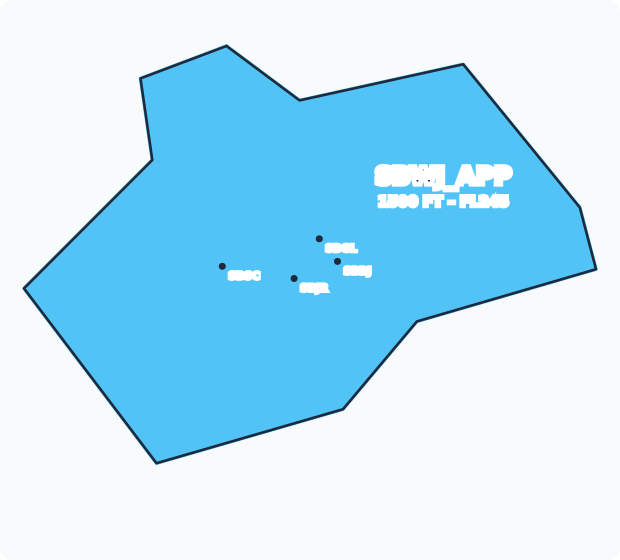
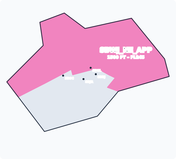
The APP is split into sectors, each with its own position and frequency in the package. Turn on the APP sectors layer on the map to see them, or the layer of a combined position to see the consolidated area it covers. Who takes over a closed sector is shown under Combined positions and in the coverage diagram.
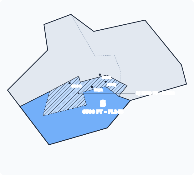
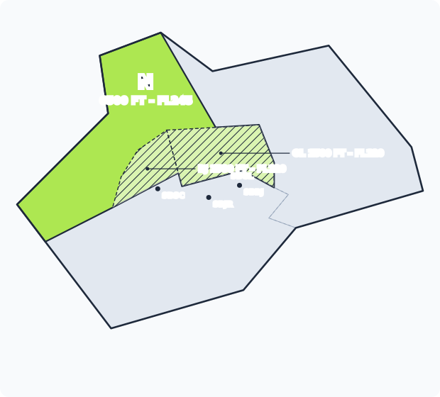
Pick an area in the list: the whole TMA (one position for everything), a combined position or an elementary sector. The area is filled, with its vertical limits below the name; the rest of the TMA is grey. Hatched: the part of the sector that belongs to a low sector (RJ or GL) below FL120.
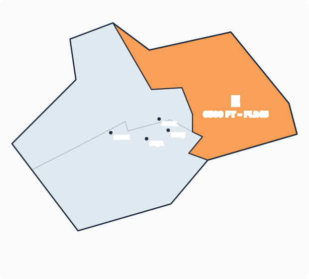
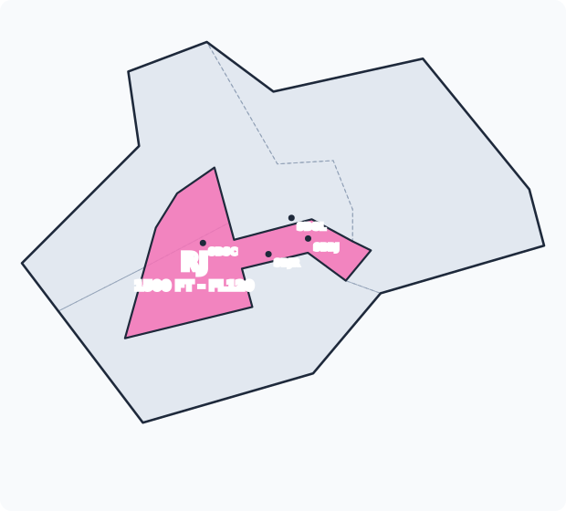
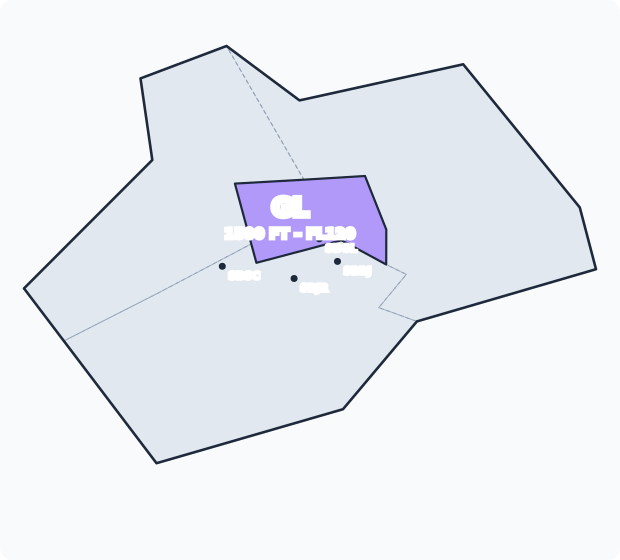
| Sector | Position | Frequency | Limits | Role | Coverage |
|---|---|---|---|---|---|
| S | SBWJ_S_APP | 126.200 | 6500 FT – FL245 | Upper sector to the south and over the sea; also Tubulão Sul | SBWJ_APP |
| N | SBWJ_N_APP | 125.950 | 6500 FT – FL245 | Upper sector to the north and west; also Tubulão Norte | SBWJ_NE_APP |
| E | SBWJ_E_APP | 133.300 | 6500 FT – FL245 | Upper sector to the east, out to the lakes region | SBWJ_NE_APP |
| RJ | SBWJ_RJ_APP | 120.750 | 1500 FT – FL120 | Low sector over SBRJ, SBJR and SBSC | SBWJ_N_APP / SBWJ_S_APP |
| GL | SBWJ_GL_APP | 128.900 | 1500 FT – FL120 | Low sector over SBGL and SBAF | SBWJ_N_APP |
- Upper sectors (S, N, E): split the TMA from 6500 ft to FL245, where the ACC entries and exits and the Tubulão are.
- Low sectors (RJ, GL): sit under S and N, from 1500 ft to FL120, around the main aerodromes. With RJ or GL closed, the upper sector above takes over the low layer (see Coverage).
Combined positions
| Position | Frequency | Takes over |
|---|---|---|
SBWJ_APP | 119.000 | SBWJ_S_APP, SBWJ_NE_APP |
SBWJ_NE_APP | 120.550 | SBWJ_N_APP, SBWJ_E_APP |
Delegated and subordinate airspace
Tubulão (delegated by Curitiba ACC)
The Tubulão is the Curitiba FIR corridor between the São Paulo and Rio de Janeiro TMAs, used by the Rio–São Paulo shuttle. In the package, Curitiba ACC (SBCW_CTR) delegates this airspace to Rio APP, split into two halves. Turn on the Tubulão layer on the map to see them.
| Sector | Limits | Position | Coverage |
|---|---|---|---|
| Tubulão North (CTA T8N) | FL105 – FL245 | SBWJ_N_APP | SBWJ_NE_APP → SBWJ_APP |
| Tubulão South (CTA T8S) | FL105 – FL245 | SBWJ_S_APP | SBWJ_APP |
| Tubulão North (UTA T8N) | FL245 – FL600 | SBWJ_N_APP | SBWJ_NE_APP → SBWJ_APP |
| Tubulão South (UTA T8S) | FL245 – FL600 | SBWJ_S_APP | SBWJ_APP |
Above FL245, the UTA T8N and T8S sectors also cover the projection of the Rio de Janeiro TMA. With every Rio APP position offline, the Tubulão returns to Curitiba ACC, starting at SBCW_E_CTR.
Aldeia Control (SBES_APP)
São Pedro da Aldeia APP (SBES_APP, Aldeia Control, 119.450) controls CTR Aldeia 1 (2000 FT – 6500 FT), inside the Macaé TMA. In the package it is subordinate to Rio APP, not to Macaé APP: when it is offline, CTR Aldeia 1 passes to SBWJ_E_APP, then SBWJ_NE_APP and SBWJ_APP. CTR Aldeia 2 (GND – 2000 FT) belongs to Aldeia Tower (SBES_TWR) and, without it, goes up to SBES_APP.
ATC Units
| Code | Abbr. | Callsign | Frequency | Remarks |
|---|---|---|---|---|
| SBWJ_APP | WJ | Rio Control | 119.000 | |
| SBGL_TWR | TGL | Galeão Tower | 118.200 | |
| SBRJ_TWR | TRJ | Rio Tower | 118.700 | |
| SBSC_TWR | TSC | Santa Cruz Tower | 118.800 | |
| SBAF_R_TWR | RAF | Afonsos Radio | 118.900 | |
| SBJR_TWR | TJR | Jacarepaguá Tower | 118.400 | |
| SBES_APP | XES | Aldeia Control | 119.450 | Subordinate to Rio APP |
Top-down coverage
Read from bottom to top: when a position is offline, the airspace falls to the next online position above.
Show coverage diagram
---
config:
  flowchart:
    wrappingWidth: 1000
---
flowchart BT
    p0["SBCW_CTR"]:::ctr
    g0["<span style='display:inline-block;margin:0 6px;padding:8px 14px;border:2px solid rgb(138,86,201);background:var(--md-mermaid-node-bg-color);color:var(--md-mermaid-label-fg-color)'>SBCW_CSE_CTR</span><span style='display:inline-block;margin:0 6px;padding:8px 14px;border:2px solid rgb(138,86,201);background:var(--md-mermaid-node-bg-color);color:var(--md-mermaid-label-fg-color)'>SBCW_CWE_CTR</span>"]:::grpctr
    g1["<span style='display:inline-block;margin:0 6px;padding:8px 14px;border:2px solid rgb(138,86,201);background:var(--md-mermaid-node-bg-color);color:var(--md-mermaid-label-fg-color)'>SBCW_CE_CTR</span><span style='display:inline-block;margin:0 6px;padding:8px 14px;border:2px solid rgb(138,86,201);background:var(--md-mermaid-node-bg-color);color:var(--md-mermaid-label-fg-color)'>SBCW_SE_CTR</span>"]:::grpctr
    p1["SBCW_E_CTR"]:::ctr
    p2["SBWJ_APP"]:::app
    p3["SBWJ_NE_APP"]:::app
    p4["SBWJ_N_APP"]:::app
    p5["SBWJ_GL_APP"]:::app
    p6["SBGL_TWR"]:::twr
    p7["SBWJ_S_APP"]:::app
    p8["SBWJ_RJ_APP"]:::app
    p9["SBRJ_TWR"]:::twr
    p10["SBSC_TWR"]:::twr
    p11["SBAF_R_TWR"]:::twr
    p12["SBJR_TWR"]:::twr
    p13["SBWJ_E_APP"]:::app
    p14["SBES_APP"]:::app
    a0(["Rio de Janeiro TMA"]):::esp --> p2
    a1(["Galeão CTR"]):::esp --> p6
    a2(["Rio CTR (SBRJ)"]):::esp --> p9
    a3(["Santa Cruz CTR"]):::esp --> p10
    a4(["Afonsos CTR"]):::esp --> p11
    a5(["Jacarepaguá ATZ"]):::esp --> p12
    a6(["CTR Aldeia 1"]):::esp --> p14
    a7(["Tubulão North"]):::esp --> p4
    a8(["Tubulão South"]):::esp --> p7
    g0 --> p0
    g1 --> g0
    p1 --> g1
    p2 --> p1
    p3 --> p2
    p4 --> p3
    p5 --> p4
    p6 --> p5
    p7 ---> p2
    p8 --> p7
    p9 --> p8
    p10 --> p8
    p11 --> p5
    p12 --> p8
    p13 --> p3
    p14 --> p13
    classDef esp stroke-dasharray:4 3
    classDef twr stroke:#2e9e5b,stroke-width:2px
    classDef app stroke:#2f7fd1,stroke-width:2px
    classDef ctr stroke:#8a56c9,stroke-width:2px
    classDef grpctr fill:none,stroke:#8a56c9,stroke-dasharray:4 3
VFR circulation
Visual navigation documents
- Circular: AIC N 30/26 – Circulação VFR nas TMA-RJ e suas projeções
- Circular: AIC N 15/16 – Regras de Apresentação de Plano de Voo para Voos VFR dentro dos limites laterais da TMA-SP e TMA-RJ (effective 13 OCT 2016)
- Visual chart – Aircraft routes (REA): CCV REA WJ1-Rio de Janeiro
- Visual chart – Helicopter routes (REH): CCV REH WJ2-Rio de Janeiro
- Visual chart – Helicopter routes (REH): CCV REH WJ3-Rio de Janeiro
- Visual chart – Helicopter routes (REH): REH Bacia de Santos
- Visual chart – Ultralight routes (REUL): CCV REUL WJ3-Rio de Janeiro
The charts are embedded in the Visual Charts tab under Useful Information. The data in this section comes from AIC N 30/262.
TMA layers and who handles VFR
TMA Rio de Janeiro has three layers. The two lower ones exist mainly for visual flight: VFR traffic crosses the metropolitan area through corridors (REA) whose maximum altitudes keep it below the IFR flows.
| Layer | Limits | Class | VFR |
|---|---|---|---|
| Rio 1 | 6500 FT (exclusive) – FL245 | C up to FL145, A above | Only with an APP clearance |
| Rio 2 | 3500 FT (exclusive) – 6500 FT | C | Corridors are mandatory |
| Rio 3 | 1000 FT (exclusive) – 3500 FT | C | Corridors are mandatory |
| Below the TMA | Below the layers, outside CTRs, ATZs and FIZs | G | Free, with coordination on the FCA |
- In the real world, the REAs in Rio 2 and Rio 3 belong to the APP-RJ Visual sector, on 133.300 (primary) and 126.200 (secondary). The same frequencies give flight information, alerting and QNH to class G traffic below the TMA.
- In the package there is no Visual sector: VFR traffic in the corridors goes to the APP sector that covers the segment, or to whoever takes it over (see top-down coverage). Turn on the Visual corridors (REA) and APP sectors layers on the map to see who works each segment. With only
SBWJ_APPonline, it handles everything. - In the package, 133.300 and 126.200 are also the frequencies of
SBWJ_E_APPandSBWJ_S_APP. Pilots call the frequency of the position that is online, not the real-world one. - In class C, the APP separates IFR from IFR and IFR from VFR. Between two VFR flights it gives traffic information.
General VFR rules
- Mandatory corridors: VFR traffic in Rio 2 and Rio 3, in the CTRs, in the ATZs of controlled aerodromes and in the FIZs below the TMA flies the published routes, at the published tracks and altitudes, unless ATS instructs or clears otherwise.
- Keep right: aircraft fly to the right of the corridor centreline. All REAs are two-way and 3 NM wide (1.5 NM each side of the centreline).
- The maximum altitude separates VFR from the IFR traffic above: breaking it means a conflict with IFR. The minimum altitude is the obstacle clearance altitude of the segment; below it, the pilot is responsible.
- Descent: in controlled airspace, plan to be at the maximum altitude from the position where it starts to apply.
- CTRs and ATZs: enter and leave through the gates, unless ATC instructs otherwise. Call the unit before entering a CTR, ATZ or FIZ.
- Speed: 200 kt IAS maximum in controlled airspace.
- Reporting: when crossing a reporting position, report on the ATC frequency or on the FCA of that segment.
- Crossing IFR tracks: crossing IFR departures and arrivals at a conflicting altitude requires an ATS clearance.
- Transponder on (mode A/C or S) in the whole area, class G included. Without an ATC code, aeroplanes squawk 2000 and helicopters 0100 between places without an ATS unit.
- QNH below the TMA: SBGL, SBRJ or SBJR ATIS. Without an ATIS, the APP gives the QNH.
- Flights from outside controlled airspace entering the TMA via the REA or REH corridors are exempt from filing a flight plan, but must first report registration, position, persons on board, endurance, origin and destination.
Visual corridors (REA)
The seven aeroplane corridors of the TMA. Altitudes in feet (QNH), as maximum / minimum. Bold marks a mandatory maximum; elsewhere the maximum is recommended. Tracks are given outbound / inbound.
| REA | Segment | Tracks | Altitudes | Airspace · contact |
|---|---|---|---|---|
| ALFA | ARARA ⇄ PIRAÍ | 036° / 216° | 6500 / 2800 | G · FCA Oeste 134.450 |
| PIRAÍ ⇄ VERDE | 036° / 216° | 6500 / 4100 | G · FCA Oeste 134.450 | |
| BRAVO | GRANDE ⇄ MANGA | 038° / 218° | 6500 / 1600 | G · FCA Oeste 134.450 |
| MANGA ⇄ SERRA | 038° / 218° | 5500 / 3500 | G · FCA Oeste 134.450 | |
| SERRA ⇄ ARARA | 055° / 235° | 5000 / 3500 | G · FCA Oeste 134.450 | |
| CHARLIE | PONTAL ⇄ POSSE ⇄ CLUBE | 008° / 188° | 3500 | C · APP-RJ 133.300 |
| CLUBE ⇄ KEMA | 008° / 188° | 3000 / 1600 | C · APP-RJ 133.300 | |
| KEMA ⇄ CUNHA | 008° / 188° | 3500 / 1500 | C · APP-RJ 133.300 | |
| CUNHA ⇄ SANTA | 008° / 188° | 3500 / 3000 | C · APP-RJ 133.300 | |
| SANTA ⇄ VASSO | 008° / 188° | 6500 / 3400 | G · FCA Oeste 134.450 | |
| VASSO ⇄ PRETO | 043° / 223° | 6500 / 3300 | G · FCA Oeste 134.450 | |
| DELTA | MANSA ⇄ PIRAÍ | 096° / 276° | 6500 / 2600 | G · FCA Oeste 134.450 |
| PIRAÍ ⇄ VASSO | 096° / 276° | 6500 / 3100 | G · FCA Oeste 134.450 | |
| VASSO ⇄ PARA | 076° / 256° | 6500 / 3100 | G · FCA Oeste 134.450 | |
| ECHO | MANSA ⇄ ARARA | 136° / 316° | 6500 / 2800 | G · FCA Oeste 134.450 |
| ARARA ⇄ GUANDU | 136° / 316° | 4500 / 2800 | G · FCA Oeste 134.450 | |
| GUANDU ⇄ VIÚVA | 136° / 316° | 3000 / 1700 | C · APP-RJ 133.300 | |
| VIÚVA ⇄ KEMA | 107° / 287° | 2500 / 1500 | C · APP-RJ 133.300 | |
| KEMA ⇄ METROPOLITANO ⇄ OUTLET ⇄ MIRIM ⇄ MAGÉ | 107° / 287° | 1500 | C · APP-RJ 126.200 | |
| MAGÉ ⇄ MANI | 160° / 340° | 1500 / 1000 | C · APP-RJ 126.200 | |
| MANI ⇄ TUBOS | 116° / 296° | 2500 / 1000 | C · APP-RJ 126.200 | |
| TUBOS ⇄ BONITO | 116° / 296° | 3500 / 2500 | C · APP-RJ 126.200 | |
| BONITO ⇄ OASIS | 116° / 296° | 3500 / 2500 | G · FCA Leste 122.150 | |
| OASIS ⇄ LAGOS | 121° / 301° | 2500 / 1100 | G · FCA Leste 122.150 | |
| FOXTROT | PONTA ⇄ GRANDE | 101° / 281° | 6500 / 1000 | G · FCA Oeste 134.450 |
| GRANDE ⇄ MARA | 101° / 281° | 4500 / 1000 | C · APP-RJ 133.300 | |
| MARA ⇄ GRAMA ⇄ PONTAL | 096° / 276° | 4500 / 1000 | C · APP-RJ 133.300 | |
| PONTAL ⇄ SENNA ⇄ TIJUCAS ⇄ RONDA | 108° / 288° | 3000 / 1300 | C · APP-RJ 133.300 | |
| RONDA ⇄ ILHA ⇄ FANTE | 103° / 283° | 2000 / 1300 | C · APP-RJ 126.200 | |
| FANTE ⇄ PRAIA DE JACONÉ | 103° / 283° | 3000 / 1500 | C · APP-RJ 126.200 | |
| PRAIA DE JACONÉ ⇄ SAQUA | 102° / 282° | 3500 / 1500 | G · FCA Leste 122.150 | |
| SAQUA ⇄ LAGOS ⇄ RIO SÃO JOÃO ⇄ MORRO | 064° / 244° | 2000 / 1500, then 1100 | G · FCA Leste 122.150 | |
| GOLF | BAÍA ⇄ MANGA | 095° / 275° | 6500 / 2300 | G · FCA Oeste 134.450 |
What each corridor does and where the traps are:
- ALFA and DELTA cross the Paraíba valley in Rio de Janeiro state (Piraí, Vassouras, Paraíba do Sul) in class G, below Rio 1.
- BRAVO links Ilha Grande and Mangaratiba to Piraí over the Serra do Mar. Watch for traffic in Angra bay, in the Mangaratiba ATZ and military traffic at SBSC.
- CHARLIE is the north-south axis of the west of the city: it leaves the coast (PONTAL), passes Posse, Clube Paradiso, Queimados and Japeri and climbs to Vassouras and Rio Preto. It is mandatory and controlled from PONTAL to SANTA, below the SBGL and SBSC arrivals. To SBAF: REALENGO gate. To SBSC: COSMO gate.
- ECHO is the main east-west axis: from Barra Mansa across the Baixada (Queimados, Arco Metropolitano, Magé), around the head of Guanabara Bay and along the Via Lagos to Araruama. Between KEMA and MAGÉ the maximum is 1500 ft, below the SBGL finals. To SBGL: ROXO gate (MAUÁ only when cleared by the APP or Galeão Tower). Entering prohibited area SBP 308 JAPERI (GND – 3000 ft) is forbidden. For the Aldeia CTR: call
SBES_APPand use the IGUABA gate. - FOXTROT is the coastal corridor: from Paraty past Ilha Grande, Marambaia, Barra da Tijuca, the islands off Guanabara Bay (Tijucas, Redonda, Rasa) and along the coast to Saquarema and Rio São João. Between RONDA and FANTE, off the bay entrance, the maximum is 2000 ft, below the SBRJ and SBGL arrivals. The GRANDE – PONTAL segment closes when restricted areas SBR 316 ATLÂNTICO or SBR 363 ATLÂNTICO CURTO are active. For the Aldeia CTR: IGUABA or TAMOIOS gates.
- GOLF links Paraty bay to Mangaratiba over Angra bay, in class G.
- Link to the São Paulo coast: at PONTA (FOXTROT) and BAÍA (GOLF), westbound traffic changes from FCA Oeste to FCA Litoral 122.925.
Aerodrome gates
Entering and leaving CTRs and ATZs with gates is always through the gates, unless ATC instructs otherwise. Gates are 1 NM wide.
| Aerodrome | Gate | Use |
|---|---|---|
| SBGL | ROXO · MAUÁ | Entering and leaving the circuit, as cleared. To join ECHO: MAUÁ on departures from RWY 10 and 15, ROXO on departures from RWY 28 and 33 |
| SBRJ | ITAIPU · SÃO GONÇALO · BOCA | Entry: ITAIPU or SÃO GONÇALO. Exit to ECHO: SÃO GONÇALO. Exit to FOXTROT: BOCA (RWY 20) or ITAIPU (RWY 02) |
| SBJR | MARAPENDI · BARRA · CURICICA | Depends on the runway in use (table below) |
| SBAF | REALENGO | Entering and leaving the circuit |
| SBAF / SBJR | TAQUARA (marked by VALQUEIRE) | Only for the link between SBAF and SBJR |
| SBSC | COSMO · RESTINGA | Entering and leaving the Santa Cruz CTR |
| SBES | IGUABA · TAMOIOS | Aldeia CTR, with SBES_APP |
SBRJ (Rio CTR). Aeroplanes use the east circuit; helicopters the west one, entering via the CATEDRAL position.
- Entry via ITAIPU: after the gate, turn right to Piratininga Lagoon, overfly the lagoon, then the ICARAÍ position to join the circuit, unless Rio Tower instructs otherwise.
- Exit to FOXTROT departing 02R/02L: head for ICARAÍ, then Piratininga Lagoon, leaving the CTR via the ITAIPU gate. Departing 20R/20L: BOCA gate.
- Exit to ECHO: SÃO GONÇALO gate.
- Watch for hang gliders in SBR 325 CHARITAS and ships at anchor in Guanabara Bay.
SBJR (Jacarepaguá CTR). The flow depends on the runway:
| SBJR runway | Entry | Exit |
|---|---|---|
| 03 | MARAPENDI | BARRA or CURICICA |
| 21 | BARRA or CURICICA | MARAPENDI |
- Watch for helicopters crossing on REH RECREIO, ultralights west of the field and parachuting in SBR 396 PRAIA DA RESERVA – GOLF.
SBSC (Santa Cruz CTR). To cross Sepetiba Bay towards Angra, traffic asks Santa Cruz Tower (118.800) for clearance at the CETEX position. In the opposite direction, before the north side of Ponta Grossa da Marambaia. No traffic enters the restricted areas in the CTR (SBR 309, 313, 314, 333, 377 and 346) without a Tower or APP clearance.
Z flight plans, entering from above and special VFR
- Z flight plan (VFR to IFR) departing SBGL, SBRJ, SBJR, SBSC or SBAF: the first segments follow the REAs, and the aircraft waits for the APP clearance to change flight rules. Where the REA is not mandatory, it flies in class G below Rio 1, at 6500 ft maximum, until the APP clears the change.
- Arriving from São Paulo or the northern São Paulo coast above 6500 ft: VFR traffic calls Rio APP at least 5 minutes before entering Rio 1 (class C) and only enters when cleared.
- Special VFR at SBJR, SBGL, SBSC and SBRJ may be cleared by Rio APP, which sets the conditions. At SBES, by
SBES_APP. - With IFR approaches to SBRJ RWY 02R, VFR departures to FOXTROT route via Icaraí, Piratininga Lagoon and the Itaipu gate.
Uncontrolled airspace below the TMA (FCA)
In class G below the TMA, coordination between aircraft is mandatory on the regional air-to-air frequencies (FCA):
| FCA | Frequency | Where |
|---|---|---|
| Oeste | 134.450 | West of the TMA: REAs ALFA, BRAVO, DELTA and GOLF and the west ends of CHARLIE, ECHO and FOXTROT |
| Leste | 122.150 | Lakes region: east ends of ECHO and FOXTROT |
| Centro | 130.550 | Helicopters over the city centre (REH perimeter) |
| Praia | 123.625 | Helicopters and the REUL along the south zone and Barra beaches |
| Litoral | 122.925 | Coast west of PONTA and BAÍA, towards São Paulo |
- ATZs without an ATS unit but with their own FCA: Angra (SDAG) 125.275 and Mangaratiba (SDCZ, SDPA) 126.025.
- On VATSIM the FCAs are not positions: with no ATC online, pilots use UNICOM 122.800. With the APP online, VFR traffic in class G may ask it for flight information.
Helicopters (REH) and ultralights (REUL)
- The REHs form the helicopter network over the city, mostly between 500 and 2000 ft, 250 m half-width in class G and 100 m in CTRs and ATZs. They are two-way, keep right. The full layout is on the REH WJ2 and REH WJ3 charts and on the Helicopter routes (REH) layer of the map, with altitudes and contact per segment.
- A helicopter off the REHs in controlled CTRs and ATZs joins or leaves the nearest REH by the shortest route, without crossing runway alignments or IFR tracks unless cleared by ATC.
- Mandatory contact points: AMARELA with Jacarepaguá Tower; ARMADA with Rio Tower; SARA and LUGANO with Galeão Tower; between CEASA and MOCIDADE with Afonsos Radio.
- Below ECHO, REHs ARCO, CLUBE, DUTRA, RURAL and MAGÉ are capped at 1000 ft; below CHARLIE, REHs ARCO, BRASIL, DUTRA, GROTA and LIGHT at 2000 ft.
- The REUL links SIWV (CAER) to SIAN (Clube CEU) along the Recreio and Grumari shore, 1200–1300 ft maximum, two-way, 250 m half-width. Up to CABRITOS it uses FCA Praia; then FCA Oeste. Between RIO DESIGN and OLÍMPICO, ultralights fly the centreline, between the Jacarepaguá ATZ and parachuting area SBR 396. At OLÍMPICO it crosses REH PRAIA (max. 600 ft) and the SBJR CURICICA gate (min. 1300 ft). Turn on the Ultralight route (REUL) layer on the map.
Phraseology
On first contact, the pilot keeps it short: station, registration, corridor, position, altitude and heading2. Brazilian VFR traffic usually calls in Portuguese:
PR-ATM, Controle Rio, identificado. Prossiga no corredor CHARLIE, máximo 3000 pés, ajuste 1015. Reporte POSSE.
The same in English:
PR-ATM, Rio Control, identified. Continue on corridor CHARLIE, maximum 3000 feet, QNH 1015. Report POSSE.
Helicopter on an REH:
Torre Jacarepaguá, PR-PAA, corredor PRAIA, posição PRAÇA, 600 pés, proa OLÍMPICO, para cruzamento da ATZ.
In class G, on the FCA (UNICOM on VATSIM):
Remarks
- Rio 1 is class A between FL145 and FL245 and class C between 6500 FT and FL145.
- The package does not split the Rio 1, 2 and 3 volumes: the map shows the TMA lateral outline, formed by the union of the APP sectors.
- SBSC (Santa Cruz) and SBAF (Afonsos) are Air Force bases: civil aircraft require authorization from the base command. SBMI (Maricá) lies in a class G FIZ.
Back to the Curitiba FIR terminals overview.
-
Frequency in the VATSIM Brasil sector package. ↩
-
AIC N 30/26, items 3 to 6 and Annexes A, C, D and F; CCV REA WJ1-Rio de Janeiro chart. ↩↩