SBNF - Navegantes
General Information
| Information | |
|---|---|
| Aerodrome name | Navegantes - Ministro Victor Konder |
| Type of Operation | International and Public |
| Transition altitude | 9000 ft7 |
| Elevation | 18 ft (6 m) |
| Largest aircraft | Code 4C3 |
| Airspace | Navegantes CTR, class C, GND/1500 ft7 |
| Accepts A380? |
Useful Information
Select one of the tools in the tabs above (Charts, Weather or Traffic) to access the aerodrome information.
Runways
Runway system
SBNF has one runway, 08/26 (1800 × 45 m, asphalt), and no parallel taxiway. The aprons are on the south side, mid-field, and connect to the runway only through TWY A and B. To depart, aircraft enter the runway via A or B, backtrack to the threshold and turn around on the turn pad at the runway end.
-
Runway
08
RNP approaches. Departure from the threshold after backtracking from A.
-
Runway
26
RNP approaches. Departure from the threshold after backtracking from B.
Runway selection
The AIP sets no preferential runway: the runway in use follows the wind. There is no ILS: both ends have non-precision approaches only2.
Runway data
| Runway | Dimensions | TORA | LDA | Approach | Remarks |
|---|---|---|---|---|---|
| 08 | 1800 × 45 m | 1800 m | 1800 m | Non-precision | RNP. PAPI1 |
| 26 | 1800 × 45 m | 1800 m | 1800 m | Non-precision | RNP. PAPI1 |
- The aerodrome accepts aircraft up to code 4C3.
- 180° turns (backtrack) for aircraft with an MTOW above 40 t only at the thresholds4.
ATC Units
| Code | Abbr. | Callsign | Frequency | Remarks |
|---|---|---|---|---|
| SBNF_ATIS | ANF | Navegantes Information | 127.625 | |
| SBNF_TWR | TNF | Navegantes Tower | 118.200 |
- The VATSIM package only has Tower: there is no Ground or Delivery, in the package or in the AIP5.
- Above Tower, top-down: SBXF_APP (Florianópolis Control, 119.650), which controls the Navegantes CTR.
- SBNF has no DCL: Tower issues the clearance by voice.
Areas of responsibility
Since Tower is the only position, SBNF_TWR controls everything: aprons, taxiways and runway 08/26.
- Departure: Tower issues the clearance, approves pushback and taxi and clears the takeoff on the same frequency.
- Arrival: Tower clears the landing and, once the aircraft has vacated the runway, the taxi to the apron.
- Pushback is mandatory for aircraft above 20 t leaving the stand6.
Ground flow
General rule
- No parallel: A and B are the only links between the runway and the apron taxiway (APN). Both split in a Y at the runway.
- Departure: enter the runway via A or B, backtrack to the threshold and turn on the turn pad.
- Landing: vacate via A or B. Aircraft that miss both turn at the runway end and backtrack.
- While the runway is occupied by a backtrack, the next aircraft holds at the holding point: one aircraft at a time on the runway.
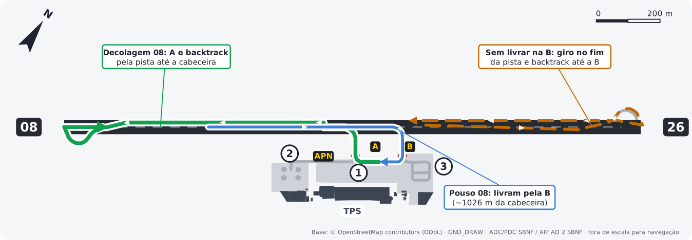
- Departures (08): APN and A to the runway, backtrack west to threshold 08 and turn on the turn pad.
- Landings (08): vacate via A (~810 m) or B (~1030 m) and follow APN to the apron. Aircraft that pass B turn at the runway end and backtrack to B.
Example: AZU4321, taxi to holding point runway 08 via A. Then: AZU4321, enter and backtrack runway 08, report ready.
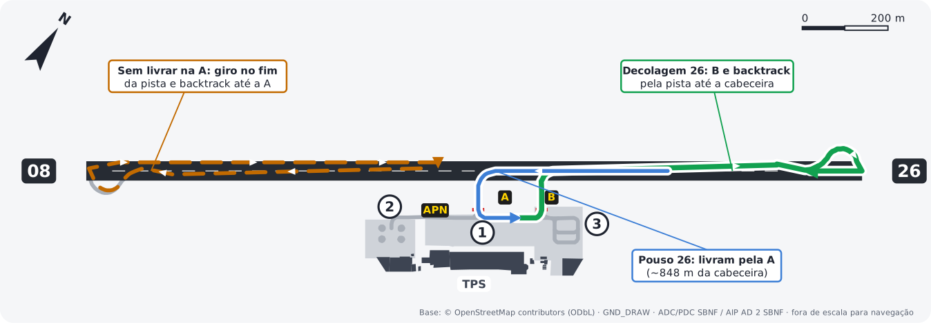
- Departures (26): APN and B to the runway, backtrack east to threshold 26 and turn on the turn pad.
- Landings (26): vacate via B (~720 m) or A (~850 m) and follow APN to the apron. Aircraft that pass A turn at the runway end and backtrack to A.
Example: GLO1234, taxi to holding point runway 26 via B. Then: GLO1234, enter and backtrack runway 26, report ready.
Runway exits
| Runway | Exits |
|---|---|
| 08 | A (~810 m), B (~1030 m) or turn at the end and backtrack |
| 26 | B (~720 m), A (~850 m) or turn at the end and backtrack |
Approximate distance from the threshold to the exit, measured on the diagram. The SBNF AIP does not publish exits.
IMC restrictions
In instrument meteorological conditions (IMC), while a code 3 or 4 aircraft (airline jets and turboprops) is landing or taking off on runway 08/26, the following are prohibited3:
- taxiing on the apron taxiway (APN);
- pushback.
Also in IMC, while an aircraft with a wingspan of 24 m or more is operating on the runway, no aircraft may taxi on the apron access taxiway parallel to the runway4. In practice: hold pushbacks and apron taxi until the landing aircraft has vacated or the departure is airborne.
Takeoff points
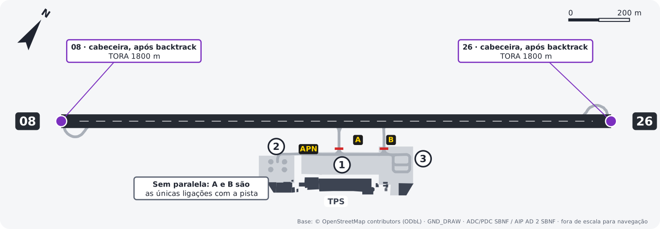
| Runway | Point | TORA | Used by |
|---|---|---|---|
| 08 | Threshold, after backtracking from A | 1800 m | All |
| 26 | Threshold, after backtracking from B | 1800 m | All |
- The SBNF AIP does not publish intersection departures.
Aprons and airlines
Reference for simulation. Stands follow the PDC charts; airlines follow the airport's airline list on Wikipedia. The split between stands is a simplification, not the airport's official allocation. VAs use the stands of the real airline they represent.



General aviation, with tie-down points.
General and business aviation.
Logos from GRU Airport. Trademarks belong to their respective airlines.
Traffic pattern
- The pattern is flown only in the northwest sector of the aerodrome8.
- Minimum pattern altitudes: CAT A and B aircraft, 1100 ft; CAT C, prohibited; helicopters, 600 ft8.
- Pattern entry8:
- from the northwest, north or northeast: head for the Containers Gate (container yard, 26 51 30S / 048 39 58W) at 1400 ft minimum and descend to pattern altitude at the gate;
- from the southwest, south or southeast: head for the Foz Gate (abeam the Itajaí River mouth, 26 53 59S / 048 38 04W) at 1100 ft minimum, cross the aerodrome and join the pattern in the northwest sector. Helicopters start descending to pattern altitude when crossing the aerodrome.
- Overflying SBNF without landing: 2400 ft minimum8.
Diagrams drawn by VATSIM Brasil over GND_DRAW and OpenStreetMap geometry (ODbL), checked against the SBNF ADC and PDC charts. Not for real-world navigation. Normative source: AIP Brasil, AD 2 SBNF, AMDT 2610A1.
-
AIP Brasil, AD 2 SBNF 2.12 and 2.13 and ADC chart. ↩↩
-
AIP Brasil, AD 2 SBNF 2.19 and IAC charts. ↩
-
AIP Brasil, AD 2 SBNF 2.17 and IAC charts. ↩↩