SBFL - Hercílio Luz
General Information
| Information | |
|---|---|
| Aerodrome name | Florianópolis - Hercílio Luz |
| Type of Operation | International, Public and Military |
| Transition altitude | 9000 ft4 |
| Elevation | 17 ft (5 m) |
| Largest aircraft | Code 4C; B757-200 under special procedures1 |
| Airspace | Florianópolis CTR, class D, GND/1500 ft4 |
| Accepts A380? |
Useful Information
Select one of the tools in the tabs above (Charts, Weather or Traffic) to access the aerodrome information.
Runways
Main and auxiliary runway
SBFL has two runways: 14/32 (2400 × 45 m, asphalt), the main runway, and 03/21 (1320 × 45 m, concrete), the auxiliary runway. They meet next to thresholds 14 and 21. D runs along 14/32 on the south side, between the runway and the new terminal (apron 1).
-
Main:
14/32
Jets and scheduled flights. ILS CAT I on 14; RNP and VOR on 32.
-
Auxiliary:
03/21
VFR only. No jets1. Threshold 21 displaced by 140 m.
HS2: thresholds 14 and 21 side by side
Thresholds 14 and 21 are very close and share the TWY A holding points. Confirm the correct runway with the pilot before clearing the line-up.
The AIP sets no preferential runway: the runway in use follows the wind.
Runway data
| Runway | Dimensions | TORA | LDA | Approach | Remarks |
|---|---|---|---|---|---|
| 14 | 2400 × 45 m | 2400 m | 2400 m | ILS CAT I | ALSF-1 |
| 32 | 2400 × 45 m | 2400 m | 2400 m | Non-precision | RNP and VOR |
| 03 | 1320 × 45 m | 1180 m | 1180 m | Visual | First 180 m closed (RESA) |
| 21 | 1320 × 45 m | 1320 m | 1180 m | Visual | Displaced threshold (140 m) |
- The AD accepts aircraft up to code 4C. The B757-200 operates under special procedures1.
- On 03/21, VFR operations only, and jet aircraft are prohibited1.
ATC Units
| Code | Abbr. | Callsign | Frequency | Remarks |
|---|---|---|---|---|
| SBFL_ATIS | AFL | Florianópolis Information | 127.450 | D-ATIS |
| SBFL_GND | GFL | Florianópolis Ground | 121.700 | |
| SBFL_TWR | TFL | Florianópolis Tower | 118.700 | DCL (code SBFL) |
DCL
SBFL has DCL (departure clearance via datalink)2. On the network, the station code is SBFL. There is no Clearance Delivery (DEL) position: the ADC chart ties the DCL to the Tower frequency.
| Station code | SBFL |
| Who operates it | SBFL_TWR. Without TWR, the position covering clearance top-down (APP or ACC) |
| Controller tool | DCL window, with your personal Hoppie ACARS code |
| Pilot tool | Aircraft ACARS or a Hoppie-compatible client, sending the clearance request to SBFL |
How it works:
- The pilot sends the request (RCD) to
SBFL, with the parking stand and ATIS letter. - The controller checks the flight plan and replies with the clearance: limit, runway, SID, transponder code, ATIS letter and next frequency.
- The pilot accepts (
WILCO/ACCEPT). The clearance is then issued and there is no voice readback. - With the clearance accepted, the pilot calls Ground for start-up or pushback.
Controller setup
- Log in to the DCL with the code
SBFLbefore opening the position. - Announce it in the controller information:
DCL AVBL LOGON SBFL. - A faulty request (invalid plan, wrong SID, no ATIS) goes back as REVERT TO VOICE: the pilot calls Tower on frequency.
- If the pilot does not accept within a reasonable time, consider the clearance not delivered and call them by voice.
Areas of responsibility
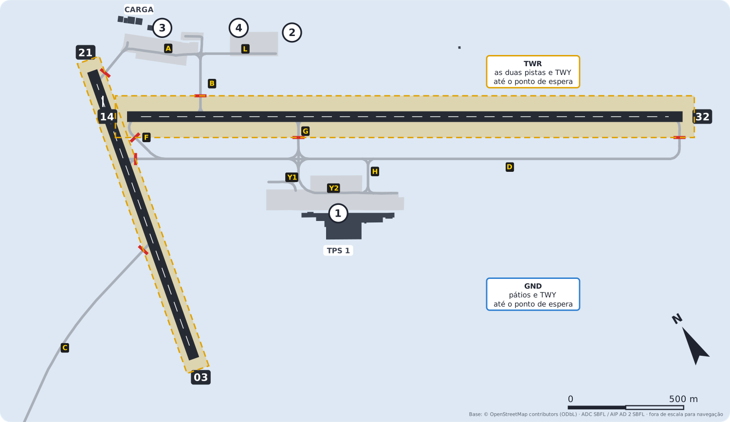
| Position | Responsible for |
|---|---|
| GND | Aprons 1 to 4 and the TWY up to the holding point |
| TWR | Both runways and the TWY inside the holding points |
- SBFL has no Apron position (APRON): Ground handles all aprons.
- Aprons 2, 3 and 4 are north of 14/32. To reach D and threshold 32, aircraft cross the runway via B, with Tower's clearance.
- Arrivals: after vacating the runway, Tower hands off to Ground.
Ground flow
General rule
- D runs along 14/32 on the south side, from threshold 14 (via F) to threshold 32. D1 to D4 are intermediate holding positions on D.
- G and H link D with apron 1; Y1, Y2 and Y3 run on apron 1. G also links D with the runway.
- To the north, A links apron 3 with threshold 21 and B links aprons 3 and 4 with 14/32; Y4 and L lead to apron 2.
- C leads to the military apron, crossing 03/21 (HS4).
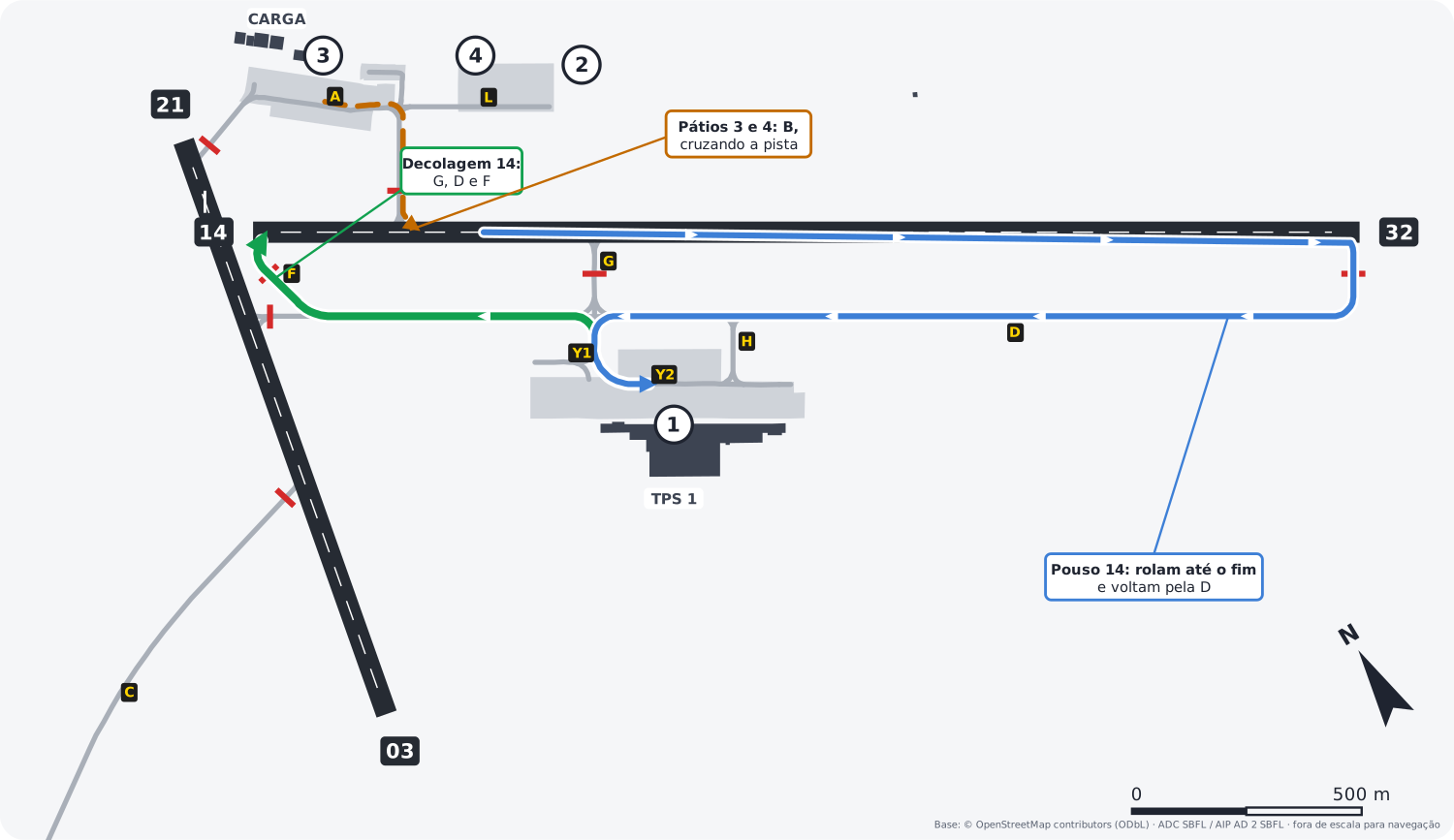
- Departures (14): from apron 1 via G, D and F to the threshold.
- Landings (14): vacate via G (~750 m, light aircraft) or roll to the end and return along D.
- Aprons 3 and 4: via B, crossing the runway, to D.
Example: AZU4321, taxi to holding point runway 14 via G, D and F.
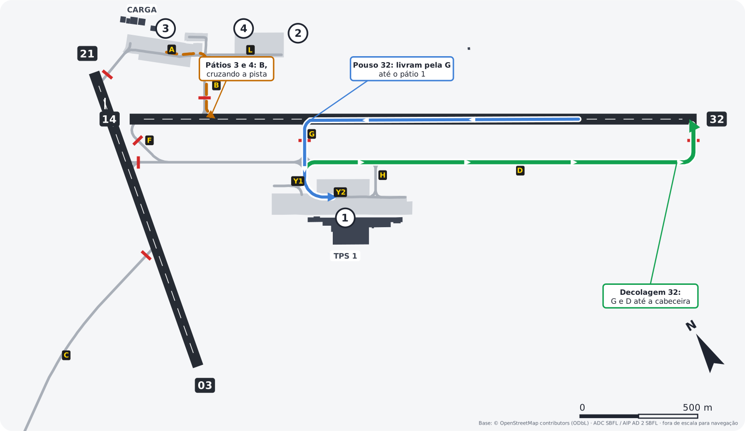
- Departures (32): G and D to threshold 32.
- Landings (32): vacate via G (~1650 m) and continue to apron 1; those rolling further vacate via F, at the end.
- Aprons 3 and 4: via B, crossing the runway.
Example: GLO1234, taxi to holding point runway 32 via G and D.
Runway exits
| Runway | Exits |
|---|---|
| 14 | B (~330 m, north side), G (~750 m) or D (end) |
| 32 | G (~1650 m), B (~2070 m, north side) or F (end) |
Approximate distance from the threshold to the exit, measured on the diagram. The SBFL AIP publishes no exits.
Hotspots
| Hotspot | Where | Watch out |
|---|---|---|
| HS1 | A, next to threshold 21 | Risk of runway incursion. TWY A allows wingspans up to 36 m |
| HS2 | Thresholds 14 and 21 | Wrong-runway departure risk: the thresholds are close and share the A holding points |
| HS3 | F and D at 03/21 | Risk of runway incursion |
| HS4 | C crossing 03/21 | Risk of runway incursion |
Taxi restrictions
| Restriction | Where |
|---|---|
| Maximum wingspan 36 m | TWY A and H and apron 1 (ADC/PDC charts) |
| Wingspan of 36 m or more | Restrictions on some TWY under own power; Tower coordinates with the airport3 |
| Maximum speed 8 kt | TWY Y2 on apron 1, for code C aircraft3 |
Takeoff points
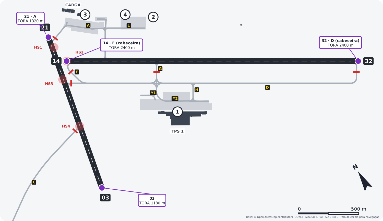
| Runway | Point | TORA | Used by |
|---|---|---|---|
| 14 | F (threshold) | 2400 m | All |
| 32 | D (threshold) | 2400 m | All |
| 21 | A (threshold) | 1320 m | Turboprops and pistons, VFR |
| 03 | Threshold | 1180 m | Turboprops and pistons, VFR |
- The SBFL AIP publishes no intersection departures.
Aprons and airlines
Reference for simulation. Stands follow the PDC charts; airlines follow the airport's airline list on Wikipedia. The split between stands is a simplification, not the airport's official allocation. VAs use the stands of the real airline they represent.








Overflow and general aviation.
General aviation and maintenance.
Logos from GRU Airport. Trademarks belong to their respective airlines.
Other procedures
- Observe the VAC for joining and leaving the traffic pattern and the local visual corridors AIC5.
- Note: around sunrise and sunset (SR and SS), sun glare may make it hard to identify the threshold cleared for landing6.
Diagrams drawn by VATSIM Brasil over OpenStreetMap geometry (ODbL), checked against the SBFL ADC and PDC charts. Not for real-world navigation. Normative source: AIP Brasil, AD 2 SBFL, AMDT 2610A1.
-
AIP Brasil, AD 2 SBFL 2.20, item 1. Declared distances: AD 2.13. ↩↩↩↩
-
AIP Brasil, AD 2 SBFL 2.18 and ADC chart. ↩
-
AIP Brasil, AD 2 SBFL 2.20, item 6 and ADC and PDC charts. ↩↩
-
AIP Brasil, AD 2 SBFL 2.17 and IAC charts. ↩↩