SBGO - Goiânia
General Information
| Information | |
|---|---|
| Aerodrome name | Goiânia - Santa Genoveva |
| Type of Operation | International and Public |
| Transition altitude | 10000 ft6 |
| Elevation | 2453 ft (748 m) |
| Largest aircraft | Code 4C (A320, B737)1 |
| Accepts A380? |
Useful Information
Select one of the tools in the tabs above (Charts, Weather or Traffic) to access the aerodrome information.
Runways
Runway system
SBGO has one runway, 14/32 (2286 × 45 m, asphalt). Two parallels run along it end to end: A on the apron 1 side (general aviation and hangars) and J on the apron 2 side (passenger terminal).
-
Runway
14
RNP, VOR and NAV APV. Takeoff from the threshold, via F or B.
-
Runway
32
RNP, VOR and NAV APV. Takeoff from the threshold, via T or E.
Runway selection
The AIP sets no preferential runway: the runway in use follows the wind.
Runway data
| Runway | Dimensions | TORA | LDA | Approach | Remarks |
|---|---|---|---|---|---|
| 14 | 2286 × 45 m | 2286 m | 2286 m | Non-precision | RNP, VOR and NAV APV |
| 32 | 2286 × 45 m | 2286 m | 2286 m | Non-precision | RNP, VOR and NAV APV |
- The AD accepts aircraft up to code 4C1.
- There is no ILS.
- 180° turns for aircraft with an MTOW above 40 t only at the thresholds2.
- When taking off from 14, do not use the extension of TWY B aligned with the runway as a landing and takeoff runway3.
- On final, do not mistake TWY J for the runway: it is on the left on final for 14 and on the right on final for 32 (hot spot HS1)3.
ATC Units
| Code | Abbr. | Callsign | Frequency | Remarks |
|---|---|---|---|---|
| SBGO_ATIS | AGO | Goiânia Information | 127.675 | |
| SBGO_DEL | DGO | Goiânia Clearance | 121.050 | Voice clearance |
| SBGO_GND | GGO | Goiânia Ground | 121.700 | |
| SBGO_TWR | TGO | Goiânia Tower | 118.700 |
- SBGO has no DCL4: clearance is given by voice on Clearance. Without DEL, the position covering clearance top-down (GND, TWR, APP or ACC) takes over.
Areas of responsibility
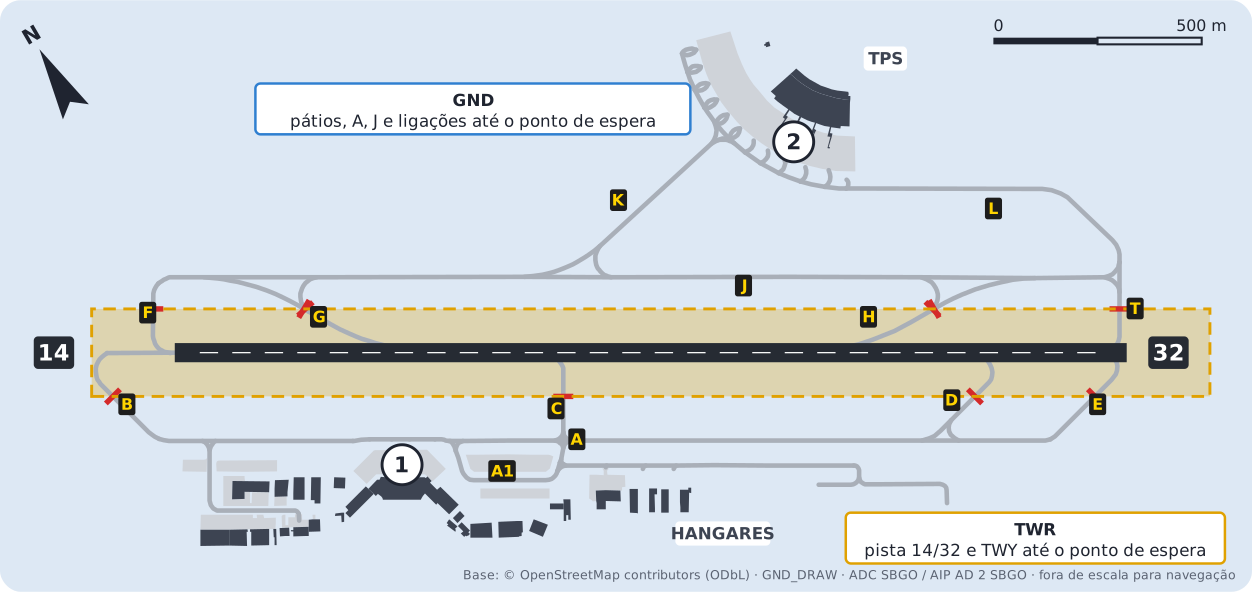
| Position | Responsible for |
|---|---|
| GND | Aprons 1 and 2, TWY A, J, K, L and the links up to the holding point |
| TWR | Runway 14/32 and the TWY inside the holding points |
- SBGO has no Apron position (APRON): Ground handles both aprons.
- The Hangares 1 and Hangares 2 taxiways are outside air traffic control: aircraft move under the operator's responsibility and call Ground before entering A5.
- Departures: Ground hands off to Tower before the holding point. Arrivals: after vacating the runway, Tower hands off to Ground.
Ground flow
General rule
- J runs along the runway on the terminal side, from F (threshold 14) to T (threshold 32).
- K links apron 2 to the middle of J; L links apron 2 to J next to threshold 32.
- A runs along the runway on the apron 1 side, from B (threshold 14) to E (threshold 32). C and D link A to the runway.
- G and H are the angled exits between the runway and J: H for aircraft landing on 14, G for aircraft landing on 32.
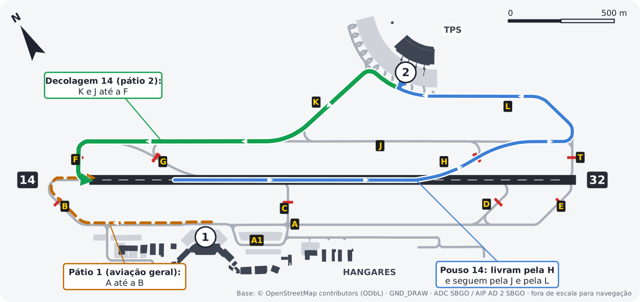
- Departures (14): from apron 2, K and J to F (threshold 14). From apron 1, A to B.
- Landings (14): vacate via H (~1530 m) and continue via J and L to apron 2. For apron 1, vacate via D (~1930 m).
Example: GLO1234, taxi to holding point runway 14 via K, J and F.
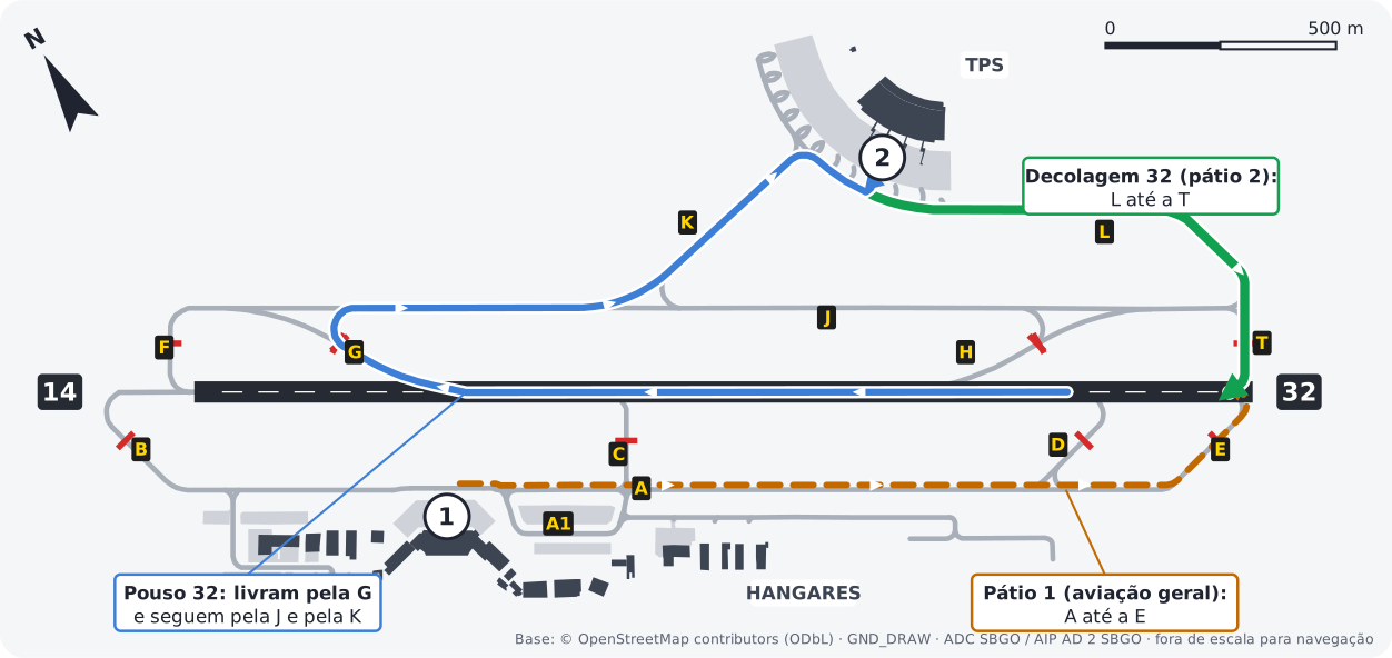
- Departures (32): from apron 2, L to T (threshold 32). From apron 1, A to E.
- Landings (32): vacate via G (~1700 m) and continue via J and K to apron 2. For apron 1, vacate via C (~1400 m).
Example: AZU4321, taxi to holding point runway 32 via L and T.
Runway exits
| Runway | Exits |
|---|---|
| 14 | C (~880 m), H (~1530 m), D (~1930 m) or T/E (end) |
| 32 | D (~350 m), C (~1400 m), G (~1700 m) or F/B (end) |
Approximate distance from the threshold to the exit, measured on the diagram. The SBGO AIP publishes no exits.
Taxi restrictions
| Restriction | Where |
|---|---|
| 180° turns | MTOW above 40 t only at the thresholds2 |
| Pushback required | Jets on scheduled flights at apron 2: leaving under own power is prohibited5 |
| Pushback before engine start | Apron 1, stands 3, 4 and 5 (in front of the TWR): code B jets and code C aircraft5 |
| Outside ATC | Hangares 1 (11 m wide) and Hangares 2 (12 m) taxiways5 |
Takeoff points
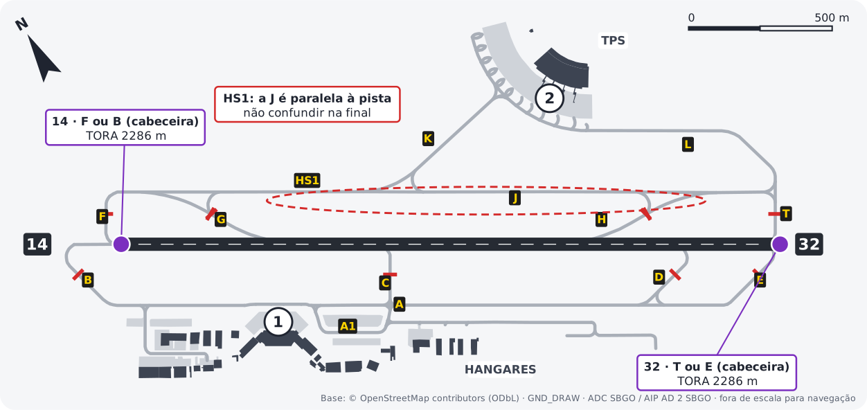
| Runway | Point | TORA | Used by |
|---|---|---|---|
| 14 | F or B (threshold) | 2286 m | All. F from the apron 2 side, B from the apron 1 side |
| 32 | T or E (threshold) | 2286 m | All. T from the apron 2 side, E from the apron 1 side |
- The SBGO AIP publishes no intersection departures.
Aprons and airlines
Reference for simulation. SBGO has no PDC chart: aprons follow the ADC chart and airlines follow the airport's airline list on Wikipedia. The split is a simplification, not the airport's official allocation. VAs use the stands of the real airline they represent.



General aviation, business aviation and air taxi. Hangars via the Hangares 1 and 2 taxiways.
Logos from GRU Airport. Trademarks belong to their respective airlines.
Other procedures
- Helicopters: landings and takeoffs directly at the Hangares 1 sector (north hangars) are prohibited. They land and take off on apron 1 or in the area next to the engine test sector and are towed to the hangar1.
- Aerobatic flights, parachute drops, dropping objects or spraying, and aircraft towing are prohibited1.
Diagrams drawn by VATSIM Brasil over the GND_DRAW geometry, derived from OpenStreetMap (ODbL), checked against the SBGO ADC chart. Not for real-world navigation. Normative source: AIP Brasil, AD 2 SBGO, AMDT 2610A1.
-
AIP Brasil, AD 2 SBGO 2.20, item 1. Declared distances: AD 2.13. ↩↩↩↩
-
AIP Brasil, AD 2 SBGO 2.23 and ADC chart. ↩↩
-
AIP Brasil, AD 2 SBGO 2.17 and IAC charts. ↩